The errors in this thread have been piling up and compounding to the point where I feel I have to set the record straight. It's difficult to know where to start, so in the interest of clarity, I have decided to begin with the first posting in the thread and take them one at a time up to the most recent posting.
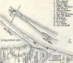
On the 1815 Saltfleet Map, scotto has stated The school house on Van Wagner's (now Baranga's) can be seen. The two-storey poured concrete Van Wagner's Beach schoolhouse with a basement wasn't built until 1905, and that building was modified several times before it was closed, and finally converted to Baranga's, and then there were more additions that brought it up to its present size. Prior to 1905, the previous schoolhouse at Van Wagner's Beach was a single storey frame building with one classroom and a separate room for the teacher. That was built around 1830 or 1840, so it would have been there (a little to the east of the later cement school) in 1875. However, it wouldn't be any larger than all the other buildings on Van Wagner's and Burlington Beach, which are represented by small black squares. Why it would be represented by such a large drawing, in a 3-dimensional side view, is a bit of a mystery. It isn't a church because the first church there was the above described frame school that was closed in 1905, when it was replaced by the cement school, and it was sold to the Anglican Church in 1917.
A large building is also shown at the cut off of what is now the entrance to Van Wagner's Beach from Beach Blvd. I have no idea what the structure was or used for, anyone In scotto's next posting, Colwyn Beynon is quoted as saying "The only large building that may have survived in 1875 may have been the Kingshead Inn. A British Army stop over and watering hole."
The King's Head Inn, formally named Government House, was burned by the Americans in May of 1813, and never rebuilt. Later buildings were built in the same area, including 2 hotels, by a father and son named Fitch. The latter Fitch's Hotel was referred to as the King's Head Inn by the local population, but it certainly wasn't frequented by the British Army. All 3 of those building were farther east, at the intersection of the Beach Road from Hamilton (which crossed the water from Red Hill Creek, or Lottridge's Creek, flowing into Burlington Bay) and the road which crossed the beach and continued along the lakeshore to Niagara-on-the-Lake.
I don't believe that structure on the map was a building at all, but rather it was the filtering basin for the Hamilton water supply. The filtering basin was originally dug around 1858, but it was enlarged more than once over the years before it was finally reduced back nearer to its original size, in the position where some of us still remember it, where the go-carts are now.
I know nothing about the lost soldier's pay.
The 1815 Admiralty Map shows the œre doubt, a cannon position, which the British put in place on the north side of the natural outlet from Little Lake to Lake Ontario, to impede an American attack by water on their fortifications on Burlington Heights, now in the Hamilton Cemetery near the High Level Bridge, during the War of 1812. I don't know what the 2 small structures are on the south bank. I think scotto just made a small slip when he wrote "the layout of the block house and battery along the sides the canal on the Burlington side." As he quickly pointed out, the fortifications were built on the Burlington outlet, the shallow crossing filled in when the present canal was built.
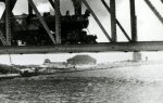
But then we have a huge error. The picture on page 58 of Harbour Lights is reported as "the first train coming over the new swing bridge from the north side in 1878" This may have been a misconception of the caption which accompanied the picture: "The first locomotive to cross the new railway swing bridge at the canal was engine J.M.Williams. It crossed the canal from the north side on January 15th, 1878. "I don't know which locomotive was the first to cross the new bridge in 1878. It may well have been the J.M.Williams, and this may very well have been the same locomotive, but it wasn't the same bridge!
The original bridge was first swung across the canal (by hand) on January 10,1877. Five days later the bridge was tested by crossing and re-crossing it at different speeds, we must assume, both ways. Regular service began the following month. The lighthouse keeper Capt. George Thomson reported in his diary that the first passenger train crossed the bridge going north on February 13th, 1877. I'm curious as to why it didn't come back until 11 months later!
But that isn't important. What is important here is that the wrought-iron bridge was replaced by a new bridge over the winter of 1902 to 1903, and the picture under consideration was believed to have been taken around 1910. (Pictures of both bridges, showing just how different they were, and including the circa 1910 photograph, can be found on page 337 of Hamilton's Other Railway by Charles Cooper)
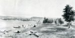
Two faint buildings, one quite large, are described as the block house and battery. Does anyone have any evidence that the fort survived until around 1910?
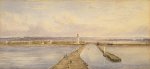
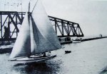
The last posting is very curious. Colwyn Beynon is quoted as writing "the picture (Burlington Bay) by John H. Caddy about 1851 shows the escarpment in the background with the Red Hill Valley point prominently in the center. You will notice on the right in the photo a tower with two windows which may be a small Martello defensive tower in common use at that time. I can't think of any other reason for a tower to be located on the north side of the canal?"
Well, I see the tower, and it's very interesting!
Caddy lived in Hamilton from 1851 to 1881, but he could also have painted it earlier, though it isn't likely (see a short bio and account of his extensive travels at
http://www.goldiproductions.com/canada_site/art/art13_caddy.html)
The water colour painting of the canal is very interesting. We are looking at the canal from Lake Ontario, and the Ocean House, built in 1875, is on the left or south side. The Railway bridge is on the north side. I don't see any signs of the buildings near the lakeshore described as a blockhouse and battery! This has to have been painted between 1875 and 1881, and if the 2 buildings seen in the train-on-the-bridge picture weren't there, they must have been built between 1881 and ~1910!
Returning to the first picture, how does Colwyn place it as north of the canal?
If Little Lake (later called Burlington Bay) is on the left, then we must be looking north. Where do we stand to look north along the bayshore and see the bay on the west and the Red Hill Valley point north of us? The scene in the distance doesn't look like the "Burlington Plain" (through which Plains Road now runs), does it? I see a house nearer the Lake Ontario side, behind the tree (it may be quite a distance from the water), and I see the racks for drying nets along the bayshore. I don't know what those angled posts are for along the water line.
Perhaps we are looking south, Lake Ontario is on the left, and the point is along the escarpment when looking toward Winona and Fifty Point. But the beach seems too low. Where is the high ridge.
How sure are we that this picture is Burlington/Hamilton Beach at all? I would love to see the original picture, and read the official description of what is depicted, when it was painted, etc., and I have another idea about that tower, but I wouldn't dare even suggest it without more information.
And that brings me to the reason why I'm pulling this thread apart. I don't do it to embarrass anyone, or to show off. My research isn't based on repeating something else that has been repeated and repeated again and again. It consists of putting the picture together from a little bit here, a little bit there, with heavy reliance on original pictures and documents, comparing them with many others to build up a clear picture of the truth. False facts really screw up that process, because they interfere with the process and make it more difficult to fit all the facts together, so it's very important to make use of critical reading, and careful observation of many small details to make sure that everything is copasetic. Until I can prove something to my own satisfaction, it's only a theory. And I don't like to see other people misled by incorrect information either.
To Colwyn Beynon, please contact me. We have to talk! My mind is always open, but I need to see your evidence!
 405.2 KB Views: 217