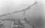
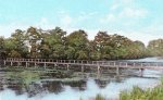
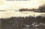
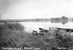
Attached are a few pictures (one is a painting) of Brant's Pond or Inlet which was located south of Joseph Brant Hospital on the harbour side. Thanks to member Drogo :hail:for the pictures and a little insight into that era (1902)
When these oldies were sent in I asked what the strip of land on the left was in photo#1?
Thanks again to Drogo!
When these oldies were sent in I asked what the strip of land on the left was in photo#1?
drogo said:
Well you can see Indian Point on the right and it appears the water was fairly shallow and there was land coming in from the left as well. As Indian Point no longer sticks out that far I would guess that it was filled in almost to that point and the inlet that was made with the land from the left. If you look at the width of the Beach Strip at the Brant end you will see that it would have required lots of land filled in to end up with enough to put the road dept. and water ponds behind JB Hospital and have enough to build two bridges and service roads.
They were from about 1902. Don't have exact dates.
When I was copying Corey information from Thompson Diaries at JB Museum there was a reference made by Thompson about two of the Coreys catching a large number of fish in one day in Brant's Pond.
They were from about 1902. Don't have exact dates.
When I was copying Corey information from Thompson Diaries at JB Museum there was a reference made by Thompson about two of the Coreys catching a large number of fish in one day in Brant's Pond.
Attachments
-
 225.9 KB Views: 93
 -
 179.1 KB Views: 94
 -
 182.7 KB Views: 96