A paper read before the Hamilton Association on May 25th, 1882, by P.S. VanWagner.
_______________________________________________________
When the grand and distinct changes which mark the different epochs in the earth's geological history had ceased, and left its surface in comparative repose, we may conjecture from certain indications observable a few miles east of Hamilton, that a large stream receiving the waters shed by that portion of country now drained by the Grand river, flowed through the passage which, at present, is in part occupied by the Big creek. The channel of this ancient river can be traced for some distance upward from the Albion mills. Down this incline towards the close of its career, it harried with increasing velocity to the smooth level rock at the foot of the Lovers' Leap. From this rock it leaped in a broad sheet with a fall of fifty feet, end entered the wild gorge below. Seething and foaming with mad fury it rushes between the high frowning walls, and emerging into the light on the lower level, flows swiftly onward through a crooked channel. Less than a mile south of the railway embankment on the Big creek, we see on the west side of the old river bed, unmistakable indications of the river having worn away the perpendicular walls of shelly red rocks. From this point it flowed slowly onward, carrying with it the drift from the cutting, above; and discharged its waters into the lake through a wide mouth, now known as Lottridge's pond.
Through the sinking of the ocean beds, (these depressions being compensated by upheaval in other portions of the earth's crust), the waters had already retired to nearly their present level, leaving Lake Ontario as the lowest basin in the chain of broad lakes. The westerly limit of this great water was at Burlington Heights, beside which, as we have been recently informed by a scientific writer, flowed at a still more remote period, a great river. Having premised the foregoing, we will now consider the probable manner in which the Burlington Beach was formed. I am not aware that this subject has been treated by any previous writer, but, if so, I wish it to be understood that I do not desire to oppose another's theory, or to disturb the learned, nor those deeply versed in geologic lore.
Violent easterly storms would, as they continue to do, wear away the southerly shore of the lake and drive forward before them the small stones, gravel and sand, washed from the banks, and deposit them and also the drift from the mouth of the Niagara beyond a cape or projection in the shore immediately east of the present mouth of the Stony creek. The clay and other fine material would be held in solution by the motion of the water, and daring a change of wind or a succeeding calm be precipitated as silt on the bottom of the lake. This will account for the deposit, whenever there is a beach, being made up of clean hard material.
As the stones, gravel and sand could not by any possibility be returned by the comparatively feeble action of the north or northwest seas, they must have continued to accumulate, filling first the mouth of the lagoon directly behind the shore projection just mentioned, thense onward along the mainland the deposit continued until it met the current at the mouth of the Old Grand River; at present Lottridge's pond. Here a struggle began between the accumulating sands and the flow of the river; but the sands prevail, and the rivers mouth is pressed aside westerly, until it reaches the spot where the water-pips leaves the south filtering basin. This old channel through which the river flowed into the lake, has bean recently obliterated by being filled up to afford the nearest roadway. This passage would be ultimately closed by heavy blows filling it with sand, and the waters thrown back a short time; and again, they burst through with great force spewing the sand out to the left, forming a long and broad beach touching the mainland. This warfare continued for a lengthened period, or until, on the occasion of an unusually dry season the river contained a small quantity of water, and a succession of east storms taking place, threw up such a mass of sand and gravel as to seal up the mouth of the river at this place forever. On an increase of its waters, the river breaks through the lighter and weaker accumulation next the mainland, and forms a new mouth in the open bay. This much narrowed channel is now spanned by the Black bridge, which unites at this point the mainland and the Beach.
The contention between the perpetually increasing sand deposit and the stream was less violent for a considerable space of time, and the beach continued to lengthen, until another stand was made at what is now called Dynes point, where we find a slip of sand running southwesterly into the bay, between which and the beach proper there is deep water, and evidently the former bed or mouth of a river, though continually becoming more shallow through the action of the waves of the bay, heaving this tongue of sand into it. Here we have the last trace of, and must bid farewell to the old Grand River. It had warred for centuries with the driving sands and had performed its part through deposits and otherwise, in the formation of the beach. Previous to its waters being withdrawn an island had formed north of its mouth, the point mentioned being the remaining south portion thereof.
As a positive proof of the sand and stones moving westerly and northerly along the shore of the lake, I may say from actual observation, that, heavy field stones used for filling cribs at the foot of the Stony Creek road, have, within twenty years, (now that the cribs have broken up), traveled a quarter of a mile northwesterly; and as one proof of the constant increasing sand deposit on the shore, I may also add, the wreak of the schooner Alvord came ashore near the Beach school-house, in May, 1868; that the bottom with the stern post attached became firmly imbedded in the sand forming an immovable land mark, and that the average water level is fully ten yards from the wreak; although the stern post had been, when first imbedded, at the waters edge.
Any obstruction on the shore gathers sand at the water’s edge.
That this ancient river ceased to discharge its waters into the lower basin, may be accounted for either by a gradual upheaval of the upper level, through which it flowed disturbing its coarse, or, by an extraordinary freshet cutting a new bed, by which it took a more southerly direction and following the deeper indentations of the surface at length formed a third, or last mouth, in the upper basin of Lake Erie.
On the southeasterly side of the bay the water is, and was, shallow, with principally a clay bottom with some alluvial deposit and fine sand. On this coarser sand and gravel continued to be deposited; and the beach grew broader and extended northward until a sort of estuary was formed, into which the heavy easterly waves rolled but to recoil from the calm deep water inside. The bottom of this estuary having been the bed of the great river before mentioned. The sand and gravel being held in a balance by the undertow, the foundation of a bar was laid, between the great sandbank on the south, and the mainland on the north, which had already pushed forward a spur made up of the drift from the north shore of the lake. The bar rose slowly in the deep water, and at length reached the surface. Additions to it, now on the lake side only; caused it to widen and increase rapidly, and the connection between the north and south shores was completed.
Birds brought grass seed and grape stones, and scorns to the new formation; and the waves wafted to it twigs of the balm, the poplar and the willow, which took root and grew. The small birds sang cheerily, the monarch eagle shrieked his approval, the fishes sported and the amphibia bellowed their praises; henceforth the new bay became a nursery and a paradise for fish and amphibious animals and water fowl.
As a result of the lengthened labors of these natural forces, we behold to-day our ever increasing and pleasant summer resort, Burlington Beach.
P. S. VAN WAGNER
May 13th 1882.
P. S. —Since writing the above I fortunately met with a reliable old resident who told me that his father had been informed, in his youth, by old Indians that their fathers remembered a wide passage from the marsh (Lottridge's pond) into the big water—Lake Ontario. This would appear to indicate that the pent up waters of Burlington Bay sometimes forced a passage at the south end of the Beach, whenever there was a greater accumulation of sand at the north end. True, the banks at the south are higher than those at the north end; this has been brought about recently by the force of the easterly waves; whereas at the north end of the Beach the heavy rise of the waves was, and is, disturbed by the rebounding pressure from the north shore of the lake. Or, as appears somewhat probable, had those Indian fathers a tradition that the old Grand River flowed into the lake at this point at a remote period? All considered, I am disposed to believe the whole Beach formation to be more recent than is generally accepted.
P. S. V. W.
July 18th, 1882,
__________________________________________________
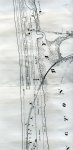
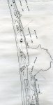
I have attached two maps (dated 1877) of the area close to that of which Mr. VanWagner was writing about, sections of the creek and pond still exsist today.
_______________________________________________________
When the grand and distinct changes which mark the different epochs in the earth's geological history had ceased, and left its surface in comparative repose, we may conjecture from certain indications observable a few miles east of Hamilton, that a large stream receiving the waters shed by that portion of country now drained by the Grand river, flowed through the passage which, at present, is in part occupied by the Big creek. The channel of this ancient river can be traced for some distance upward from the Albion mills. Down this incline towards the close of its career, it harried with increasing velocity to the smooth level rock at the foot of the Lovers' Leap. From this rock it leaped in a broad sheet with a fall of fifty feet, end entered the wild gorge below. Seething and foaming with mad fury it rushes between the high frowning walls, and emerging into the light on the lower level, flows swiftly onward through a crooked channel. Less than a mile south of the railway embankment on the Big creek, we see on the west side of the old river bed, unmistakable indications of the river having worn away the perpendicular walls of shelly red rocks. From this point it flowed slowly onward, carrying with it the drift from the cutting, above; and discharged its waters into the lake through a wide mouth, now known as Lottridge's pond.
Through the sinking of the ocean beds, (these depressions being compensated by upheaval in other portions of the earth's crust), the waters had already retired to nearly their present level, leaving Lake Ontario as the lowest basin in the chain of broad lakes. The westerly limit of this great water was at Burlington Heights, beside which, as we have been recently informed by a scientific writer, flowed at a still more remote period, a great river. Having premised the foregoing, we will now consider the probable manner in which the Burlington Beach was formed. I am not aware that this subject has been treated by any previous writer, but, if so, I wish it to be understood that I do not desire to oppose another's theory, or to disturb the learned, nor those deeply versed in geologic lore.
Violent easterly storms would, as they continue to do, wear away the southerly shore of the lake and drive forward before them the small stones, gravel and sand, washed from the banks, and deposit them and also the drift from the mouth of the Niagara beyond a cape or projection in the shore immediately east of the present mouth of the Stony creek. The clay and other fine material would be held in solution by the motion of the water, and daring a change of wind or a succeeding calm be precipitated as silt on the bottom of the lake. This will account for the deposit, whenever there is a beach, being made up of clean hard material.
As the stones, gravel and sand could not by any possibility be returned by the comparatively feeble action of the north or northwest seas, they must have continued to accumulate, filling first the mouth of the lagoon directly behind the shore projection just mentioned, thense onward along the mainland the deposit continued until it met the current at the mouth of the Old Grand River; at present Lottridge's pond. Here a struggle began between the accumulating sands and the flow of the river; but the sands prevail, and the rivers mouth is pressed aside westerly, until it reaches the spot where the water-pips leaves the south filtering basin. This old channel through which the river flowed into the lake, has bean recently obliterated by being filled up to afford the nearest roadway. This passage would be ultimately closed by heavy blows filling it with sand, and the waters thrown back a short time; and again, they burst through with great force spewing the sand out to the left, forming a long and broad beach touching the mainland. This warfare continued for a lengthened period, or until, on the occasion of an unusually dry season the river contained a small quantity of water, and a succession of east storms taking place, threw up such a mass of sand and gravel as to seal up the mouth of the river at this place forever. On an increase of its waters, the river breaks through the lighter and weaker accumulation next the mainland, and forms a new mouth in the open bay. This much narrowed channel is now spanned by the Black bridge, which unites at this point the mainland and the Beach.
The contention between the perpetually increasing sand deposit and the stream was less violent for a considerable space of time, and the beach continued to lengthen, until another stand was made at what is now called Dynes point, where we find a slip of sand running southwesterly into the bay, between which and the beach proper there is deep water, and evidently the former bed or mouth of a river, though continually becoming more shallow through the action of the waves of the bay, heaving this tongue of sand into it. Here we have the last trace of, and must bid farewell to the old Grand River. It had warred for centuries with the driving sands and had performed its part through deposits and otherwise, in the formation of the beach. Previous to its waters being withdrawn an island had formed north of its mouth, the point mentioned being the remaining south portion thereof.
As a positive proof of the sand and stones moving westerly and northerly along the shore of the lake, I may say from actual observation, that, heavy field stones used for filling cribs at the foot of the Stony Creek road, have, within twenty years, (now that the cribs have broken up), traveled a quarter of a mile northwesterly; and as one proof of the constant increasing sand deposit on the shore, I may also add, the wreak of the schooner Alvord came ashore near the Beach school-house, in May, 1868; that the bottom with the stern post attached became firmly imbedded in the sand forming an immovable land mark, and that the average water level is fully ten yards from the wreak; although the stern post had been, when first imbedded, at the waters edge.
Any obstruction on the shore gathers sand at the water’s edge.
That this ancient river ceased to discharge its waters into the lower basin, may be accounted for either by a gradual upheaval of the upper level, through which it flowed disturbing its coarse, or, by an extraordinary freshet cutting a new bed, by which it took a more southerly direction and following the deeper indentations of the surface at length formed a third, or last mouth, in the upper basin of Lake Erie.
On the southeasterly side of the bay the water is, and was, shallow, with principally a clay bottom with some alluvial deposit and fine sand. On this coarser sand and gravel continued to be deposited; and the beach grew broader and extended northward until a sort of estuary was formed, into which the heavy easterly waves rolled but to recoil from the calm deep water inside. The bottom of this estuary having been the bed of the great river before mentioned. The sand and gravel being held in a balance by the undertow, the foundation of a bar was laid, between the great sandbank on the south, and the mainland on the north, which had already pushed forward a spur made up of the drift from the north shore of the lake. The bar rose slowly in the deep water, and at length reached the surface. Additions to it, now on the lake side only; caused it to widen and increase rapidly, and the connection between the north and south shores was completed.
Birds brought grass seed and grape stones, and scorns to the new formation; and the waves wafted to it twigs of the balm, the poplar and the willow, which took root and grew. The small birds sang cheerily, the monarch eagle shrieked his approval, the fishes sported and the amphibia bellowed their praises; henceforth the new bay became a nursery and a paradise for fish and amphibious animals and water fowl.
As a result of the lengthened labors of these natural forces, we behold to-day our ever increasing and pleasant summer resort, Burlington Beach.
P. S. VAN WAGNER
May 13th 1882.
P. S. —Since writing the above I fortunately met with a reliable old resident who told me that his father had been informed, in his youth, by old Indians that their fathers remembered a wide passage from the marsh (Lottridge's pond) into the big water—Lake Ontario. This would appear to indicate that the pent up waters of Burlington Bay sometimes forced a passage at the south end of the Beach, whenever there was a greater accumulation of sand at the north end. True, the banks at the south are higher than those at the north end; this has been brought about recently by the force of the easterly waves; whereas at the north end of the Beach the heavy rise of the waves was, and is, disturbed by the rebounding pressure from the north shore of the lake. Or, as appears somewhat probable, had those Indian fathers a tradition that the old Grand River flowed into the lake at this point at a remote period? All considered, I am disposed to believe the whole Beach formation to be more recent than is generally accepted.
P. S. V. W.
July 18th, 1882,
__________________________________________________
I have attached two maps (dated 1877) of the area close to that of which Mr. VanWagner was writing about, sections of the creek and pond still exsist today.
Attachments
-
 213.8 KB Views: 116
 -
 186.7 KB Views: 122