From the Top of the Lift Bridge

scotto

Administrator
Staff member
Feb 15, 2004
6,985
218
63
The Beach Strip
#1


A photo taken by Harold "Joe" Ballantyne in the winter of 1975 from the top of the Lift Bridge.
Some of buildings are somewhat hard to visualize, but I will identify what I can;
1/ The cottage for the manager of the amusement park, Jack Greenwood
2/The Cottage Inn Restaurant
3/The bowling Alley
4/The Wild Mouse ride.
5/The Bingo Hall
6/The Arcade
7/The base for the Merry-Go-Round
8/Rotten Ralphie's
9/The Bath House
 

scotto

Administrator
Staff member
Feb 15, 2004
6,985
218
63
The Beach Strip
#3
Question for you Scott,

The Jimmy Lomax Park is where the amusement park use to be roughly ?
Jimmy Lomax Park use to have houses, one guy had a sign on the door so as not bother him as he worked straight nightshift. The parking lot that is beside the park was the start of the parking for the amusement park, then kiddie land which started across from what is now the canoe place property.
 
Last edited:

scotto

Administrator
Staff member
Feb 15, 2004
6,985
218
63
The Beach Strip
#4

I have added a couple points, it's a little hard to see as the picture is a tad dark.
11/ The short wooden fence that was entrance to Kiddie Land.
12/ The dirt parking lot
13/ Where Jimmy Lomax Park is now located.
10/The Angus Inn was located there, the building next to it was the Hels Grill which is the last remaining building (for now) at the north end of the Beach.

Missing in this picture is the pedestrian bridge went over Beach Blvd near the Merry-Go-Round, could not of been missing for very long.
 

scotto

Administrator
Staff member
Feb 15, 2004
6,985
218
63
The Beach Strip
#5
I have borrowed an aerial photo from McMaster Library of the north end of Hamilton Beach, this was taken April 21, 1960. This photo was taken well before the park opened for the summer season therefore many of the rides are missing, but I have listed the position of what I can remember.
If anyone can add anything, please post it here or email me at hbcf@cogeco.ca
 

Attachments

Last edited:

scotto

Administrator
Staff member
Feb 15, 2004
6,985
218
63
The Beach Strip
#6
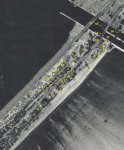
1/ What is now Dieppe Park.
2/ Was Manor Ave, there was a barber shop on the north side of Manor.
3/ Skyway Lawn Equipment.
4/ Green Gables antique store.
5/ Gas Station
6/ Hels Grill
7/ Angus Inn Restaurant.
8/ Pedestrian bridge.
9/ 77mm Gun from WWI.
10/Entrance to Kiddie Land.
11/Boat ride, directly across towards the Skyway, was the Roller Coaster.
12/Rotten Ralphie's.
13/Merry-Go-Round
14/Location of the Salt and Pepper Shaker, this ride use to empty the pockets of the riders.
15/Games building, Fish Pond, Milk Jug Toss, Knock the Bottles off, Darts and Skee Ball. At the north end was the maintenance shop.
16/Location of the Tilt a Whirl.
17/Ferris Wheel.
18/Octopus.
19/Bath House.
20/Bumper Cars.
21/The Wild Mouse ride.
22/Arcade.
23/Bingo Hall
24/Bathrooms.
25/Park Office.
26/Bowling Alley.
27/Cottage Inn
28/Park Manager's cottage.
29/Beach Baseball Diamond.
30/The remains of the Lakeside Hotel, making room for the new road coming from the Lift Bridge,
31/Lighthouse Keeper's dwellings, one still remains, the other was demolished just after the Lift Bridge was finished.
32/Lighthouse.
33/Forms for the base of the Lift Bridge south tower.
34/Bascule Bridge.
35/A section of the new span of the Lift Bridge being assembled.
36/Railway Swing Bridge.
 
Likes: Opie

scotto

Administrator
Staff member
Feb 15, 2004
6,985
218
63
The Beach Strip
#7


This is a Spectator photo from July 1958, the Skyway is nearing completion and the amusement park is open for business. I have added the picture because I have no idea what the building marked #37 is. I have asked a few of the old timers (what is left of them), but no one seems to have a solid answer. #30 is still the Lakeside House and across from our mystery building is the Cottage Inn #27.
 
Last edited:

scotto

Administrator
Staff member
Feb 15, 2004
6,985
218
63
The Beach Strip
#9
Dug this picture from one of my old folders, so I have no idea who to credit.
First building on the right is the Canal Bowling Lanes, next is the washrooms, then the bingo hall, the arcade and then the bumper cars. The Ferris wheel in the background and the pedestrian bridge is still standing. Most likely this picture was taken during the open season but the park was closed during the day except for the weekends .


OverTheRoadBridge.jpg


A shot from the opposite end,

(Spectator)
Amusement Park.jpg
 
Last edited:
Likes: maggie

scotto

Administrator
Staff member
Feb 15, 2004
6,985
218
63
The Beach Strip
#12


This is a Spectator photo from July 1958, the Skyway is nearing completion and the amusement park is open for business. I have added the picture because I have no idea what the building marked #37 is. I have asked a few of the old timers (what is left of them), but no one seems to have a solid answer. #30 is still the Lakeside House and across from our mystery building is the Cottage Inn #27.
Number 37 is actually #28, the Park Manager's cottage, a clearer picture is attached below showing the Cottage Inn directly across the street which shows little activity as it looks like the park still hasn't opened for the season. Notice the lone pile driver at the lift bridge area, starting on the south tower. There is a large amount of parked cars around the Manager's cottage in the first photo, which would mean a good day at the Lakeside Tavern (#30) and with all the vehicles parked at the ball diamond it was likely game day.
Picture courtesy Toronto Public Library
TPL2-124-go-300edit.jpg


Adding one more picture as this one shows the front of the Cottage Inn. The picture would be from the early 1970's as the hydro towers beside the lift bridge have been replaced and CCIW looks to be just finished being built.
Sorry I don't have a credit for this one.
CCIW.jpg
 

scotto

Administrator
Staff member
Feb 15, 2004
6,985
218
63
The Beach Strip
#13
An update with a couple additions.

EvansBeach.jpg

From Gary Evan's 2009 Beach Calendar

Starting with a landmark from past pictures in this thread, #7 is the Angus Inn and beside the restaurant (#40) is the Beach Commission Office which was moved in 1957 to the present day Beach Rescue Unit and used as the board room and the members club. That building was mostly demolished in 2011 and replaced with a new structure, some of the base was kept.
Just before demolition;


CommissionOffice.JPG


Number 9 is the 77mm gun from WWI, I added this because after the Commission office was moved, the gun was relocated directly across the street, some history and pictures are posted here;
http://hamiltonbeachcommunity.com/forum/threads/the-old-cannon-at-the-canal.356/


Moving to # 41, checking with some older residents, this building is believed to be a warehouse for the amusement park for winter time storage, but beside it (#42 ) is an outdoor bowling alley, it is clearly seen in the original photo and mentioned in Gary Evan's last book, "Memories of the Beach".
 
Last edited:

scotto

Administrator
Staff member
Feb 15, 2004
6,985
218
63
The Beach Strip
#15
More info from a past Beach Commissionaire, the building (#41) was used for storage in the winter, but it was the Beach Pavilion.
From Gary Evan's book;

"During the early days of the 1900s, many visitors were attracted to the area around the canal and as a result, Pavilion Park was developed to provide facilities to accommodate picnics close by where ferry boats and train excursions dropped off passengers for the day. Realizing the need to accommodate these people, in 1926 the Burlington Beach Commissioners raised debentures in the amount of $25,00 to build a new pavilion and other buildings on the grounds, and it proved to be a worthwhile expenditure as the rather large building attracted numerous picnics to the Beach, with many of the visitors travelling for some distance to enjoy
this unique experience."

Pavillon.jpg


Notice the sign- "Horses not allowed"

Slightly less dated photo, the Pavilion can be seen from the top of the lighthouse and is just past the Lakeside House.
HPL
Pavillon2b.jpg
 
Likes: Opie

scotto

Administrator
Staff member
Feb 15, 2004
6,985
218
63
The Beach Strip
#16
An update with a couple additions.

View attachment 3969
From Gary Evan's 2009 Beach Calendar

Starting with a landmark from past pictures in this thread, #7 is the Angus Inn and beside the restaurant (#40) is the Beach Commission Office which was moved in 1957 to the present day Beach Rescue Unit and used as the board room and the members club. That building was mostly demolished in 2011 and replaced with a new structure, some of the base was kept.
Just before demolition;
Just south of the Angus Inn (#7) was Hels Grill, in the above picture (view attachment 3936) there is a tractor trailer parked out front. The building is there but will be demolished in the near future for a condo development.
Hal's Grill.JPG


Also mentioned is Murray's Barber Shop which was located on the corner of Manor Ave and Beach Blvd. The barber shop was only the small square side building, the house and the one next to it are also scheduled to be demolished for one very large house.
Murray's.JPG
 
Top Bottom