HCA protests plan to fill harbour inlet

scotto

Administrator
Staff member
Feb 15, 2004
6,985
218
63
The Beach Strip
#1
Posted with permission from Stoney Creek News.

By Richard Leitner

Stoney Creek News
Dec 14, 2007
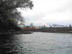
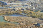
The Hamilton Port Authority is rejecting an eleventh-hour appeal to halt construction of a wharf in the east harbour that will push aside fish, turtles, beavers, coyotes and migratory birds to make way for ships.

Linda MacDonald, vice-president of operations for the federal agency, said the Pier 22 project has received all necessary approvals and will continue over the next two months as planned.

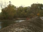
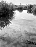
Hamilton Conservation Authority directors voted last week to try to intervene on the wharf after being told the area, known as Harris Inlet, is teeming with wildlife and includes one of the east harbour's biggest stands of mature trees.

Councillor Chad Collins said the planned filling in of two large ponds runs "in the opposite direction" of other efforts to reclaim the harbour -- including the port authority's proposed $3-million rehabilitation of Sherman Inlet.

"I just think it makes all the sense in the world that we somehow get involved and protect as much of that property as possible," he said.

"Even if it's to broker some kind of compromise and the laws are against us, I think that should raise the issue as well."

But Ms. MacDonald said the conservation authority was consulted in May as part of an environmental assessment and raised no objections then.

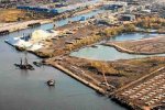
The wharf is being constructed on the northern portion of a 42-hectare property that is home to a former Stelco rod mill. The port authority bought the site a year ago.

"The construction of the wharf will be ongoing. We have followed the process, the environmental assessment and we have an approved project that we are working on," Ms. MacDonald said.

"The plan is to build a wharf, have marine traffic go to the wharf and have the land available for industrial use," she said. "It's an industrial port. We are looking to develop for industry."

Conservation authority director Jim Howlett led the push for an intervention on the project after surveying the inlet and finding several species of fish, birds and other wildlife.

The Hamilton Beach resident said maps from the early 1900s suggest industrial dumping has already filled in much of the waterway, home to an active beaver dam and coyote dens.

It is fed by a creek that in turn appears to be fed by creeks originating on the escarpment, he said.

"If you look at it, you can't really believe that it's east Hamilton Harbour," Mr. Howlett said.

"What's the difference between that and Cootes Paradise or some other great place in the west harbour? When I walked in here, I scared off two great big herons that were sitting on the banks," he said.

"There's enough tracks there to say that there's a lot of activity of different wildlife," he said. "There's hundreds of fish."

According to an environmental screening report on the project, an assessment by the Department of Fisheries and Oceans (DFO) determined that only one of the two ponds -- or "man-made depressions" -- is considered fish habitat.

Each are about three hectares and will be filled with nearly a third of the 185,000 cubic metres of sediment being dredged to provide the proper depth for ships using the wharf's 215-metre dock.

While the conservation authority was consulted last spring, it deferred to the DFO, stating it had no jurisdiction on federal lands, according to the report.

There was no public consultation.

"Due to the site specific nature of this project in an already industrialized area, formal public consultation was not deemed necessary as part of this assessment," the report states.

Mr. Howlett said he isn't trying to stop the project, but push the port authority "to be much more modern and sensitive in its land-use planning."

He said the port authority has told him it plans to compensate for the lost fish habitat at an island elsewhere in the harbour but the two sites aren't comparable.

"It seems incongruous that they're blowing trumpets about Sherman Inlet in the central harbour, but in the east harbour they're doing something far worse."
__________________________________________________________________________
 

scotto

Administrator
Staff member
Feb 15, 2004
6,985
218
63
The Beach Strip
#2
Opposition runs deep

Posted with permission from the Hamilton Spectator.
December 18, 2007
Eric McGuinness
The Hamilton Spectator
(Dec 18, 2007)
The Hamilton Port Authority is under fire for conducting an environmental assessment of a major new pier project without public input.

Lynda Lukasik, executive director of Environment Hamilton, says she can't understand the lack of consultation on the development at Harris Inlet, home to beavers, coyotes, turtles, fish and other wildlife, and a stopping place for migratory birds such as great blue herons.

"Did they ask for public input? Absolutely not," she said yesterday. "I'm very disappointed there wasn't broader public consultation."

The first phase -- under way since September -- involves construction of a dockwall on Pier 22 north of Stelco's former No. 2 Rod Mill. It involves dredging 11 hectares offshore to a depth of almost three storeys, filling large ponds with contaminated sediment and developing 15 hectares of cargo-handling space at the north end of the 42-hectare property, between Kenilworth and Strathearne avenues.

Contracts for the dredging and dockwall alone are worth $7 million. Linda MacDonald, vice-president of operations for the authority, said there is also potential to excavate a 37-metre-wide boat slip extending 250 metres inland.

In response to the criticism, she said the authority is "consulting with all the appropriate agencies" and aiming for a project "that brings economic benefits with environmentally friendly features."

At issue is the fate of what's left of Harris Creek, one of many natural waterways that once drained into the harbour, plus several ponds, wetland and a stand of mature trees. One pond at the south end of the property was in the news 18 months ago when an unidentified substance spilled, threatening large snapping turtles regularly fed by workers at the Jervis B. Webb plant on Burlington Street East.

Under the heading "consultation with the public," the port authority report says, "Due to the site-specific nature of the project in an already industrialized area, formal public consultation was not deemed necessary as part of this assessment."

Jim Howlett, a Beach Strip businessman who sits on the Hamilton Conservation Authority board, argues that natural features of the site should be preserved alongside the planned industrial uses.

"The port authority says it can do whatever it wants with the whole property, but that seems unjust, when there's a meandering stream and well- established wetland that can be saved, whether a single Hamiltonian visits it or not. The average Hamiltonian will never visit the Amazon rain forest or the back of Cootes Paradise, but they benefit from them being there."

Howlett and other conservation authority members, including city councillors Tom Jackson and Chad Collins, complained last week about the provincial conservation authority losing jurisdiction over the site when the federal port authority bought it from Stelco (now U.S. Steel) last December.

The port authority's environmental assessment began in March with no public notice. The resulting 137-page report was posted on the Canadian Environmental Assessment Act website in late July, but Lukasik asks, "How many people look there?" It's also available on the authority's website, but not highlighted like similar reports on remediation of Randle Reef and Sherman Inlet.

The federal Department of Fisheries and Oceans says some of the work will "result in harmful alteration, disruption and destruction of fish habitat," but that the port authority can compensate for and mitigate the damage. MacDonald said the authority is working on a compensation plan, but would not reveal what's being considered.

emcguinness@thespec.com

905-526-4650

Hamilton Spector File Photos
#1- Environmentalists say concerns about related wetlands deserve more public examination than was given.
#2- Phase 1 of a multimillion-dollar pier project -- begun in September -- involves dredging at Harris Inlet.
 

Attachments

scotto

Administrator
Staff member
Feb 15, 2004
6,985
218
63
The Beach Strip
#3
Fish habitat destruction feared

Stories by Eric McGuinness
The Hamilton Spectator
(Dec 28, 2007)
Lake Ontario waterkeeper Mark Mattson believes the federal Department of Fisheries and Oceans (DFO) can -- and should -- stop construction at Pier 22 until the Hamilton Port Authority consults the public about destruction of fish and wildlife habitat at Harris Inlet.

Mattson doesn't accept "excuses" offered by DFO and the federal port authority for skipping public input.

"First and foremost, there is a lot of public concern about this sort of work in Hamilton Harbour. So many feeder creeks and streams from the escarpment have been filled in, the last few gems have to be saved.

"DFO has the authority and ability to stop this tomorrow -- today -- and needs to be reminded of its responsibility. If others have pointed out the destruction of fish habitat and the need for public consultation, DFO can clearly put it on hold until all these legislative hurdles are overcome."

Mattson, a lawyer who heads the non-profit waterkeeper organization, doesn't accept an interpretation of the Canada Marine Act that holds port authorities exempt from provincial and municipal jurisdiction, but if it is valid, it's wrong and the act should be changed.

"Port authorities shouldn't be above the law," he said, reacting to a Spectator story that revealed a dredging and dockwall construction project for a new Pier 22 began in September after an environmental assessment held there was no need for public input because the area between Strathearne and Kenilworth avenues was industrial.

The assessment noted the presence of large ponds, mature trees, a beaver lodge, coyote dens, turtles, fish and other wildlife, but no endangered species.

DFO fish habitat biologist Rick Kiriluk said the current project does not include the Harris Inlet waterway or a large, connected pond considered to be fish habitat. He said the authority had rejigged its plans to exclude that area, but plans to make a separate proposal for it.

On the issue of public input, he said: "As the Hamilton Port Authority is the lead federal agency on this project, it is at their discretion as to whether or not they conduct public consultation."

Councillor Chad Collins, a member of the Hamilton Conservation Authority, says staff accepted too readily the notion the conservation agency has no jurisdiction on federal land. The board now wants staff to determine just how far the authority's regulatory power extends and, if it has none on Pier 22, "there's still an advocacy role for us to play."

Collins noted the port authority is prepared to spend $3 million to restore habitat it destroyed at Sherman Inlet, "while going in the opposite direction at Harris Inlet," where a stretch of the all-but-vanished Harris Creek survives.

Habitat preservation there "would be an ideal project for the conservation authority, which has taken a leadership role at Sherman Inlet and has expressed intent to take a more proactive role in inner-city Hamilton, especially brownfield industrial sites" such as the 42-hectare Pier 22 property, where Stelco operated its No. 2 Rod Mill.

Kiriluk said no DFO authorization was needed for the first phase of pier development, because fish habitat is not affected, but "any further works on the site that involve infilling or alterations to the existing pond and associated connecting channel may require a Fisheries Act authorization and fish habitat compensation."

emcguinness@thespec.com

905-526-4650

Pier plan to clear trees, fill ponds and dredge not in port's report

The Hamilton Port Authority hired an environmental manager in August 2006, proclaiming its "commitment to environmental responsibility." But its first environmental report to the public, issued last May, failed to mention the Pier 22 environmental assessment begun two months before. Environmental manager Marilyn Baxter was unavailable to explain the omission. Board chair Al Peckham, the only city appointee on the seven-member federal authority, did not return a call from The Spectator last week. A May 2 news release said the report contained an "overview on the HPA's environmental activities, as well as details on environmental programs, projects, operations and community engagement," yet the 13-page document nowhere mentioned the plan to clear trees, fill ponds and dredge eight hectares of harbour bottom to create a multimillion-dollar pier and 15 hectares of cargo-handling space. The Pier 22 Wharf Completion Project Environmental Assessment Screening Report produced by Stantec Consulting Ltd. says environmental assessment began March 20, six weeks before Baxter's report was produced. Section 7.6, titled consultation with the public, says: "Due to the site- specific nature of the project in an already industrialized area, formal public consultation was not deemed necessary as part of this assessment. The project is in conformance with the principles of the Hamilton Port Authority Land Use Plan, 2002, which was developed with public and stakeholder input."
 

scotto

Administrator
Staff member
Feb 15, 2004
6,985
218
63
The Beach Strip
#4
Port authority needs to open its doors

Lydia Cartlidge
The Hamilton Spectator
Hamilton
(Dec 29, 2007)
Re: 'Why no public input on Harris Inlet project?' group asks port authority' (Dec. 18)

Having seen so much improvement in the harbour in the past few years, I am dismayed by the direction the Hamilton Port Authority(HPA) has taken with its proposed infilling of Harris Inlet.

For decades, the inlet and the creek have been known to steelworkers as a hidden paradise behind the steel mills. Now it looks as if it will soon be known as a "paradise lost."

Hamiltonians need modern answers and modern solutions to this proposed destruction. The Bay Area Restoration Council (BARC) needs to speak up about an obvious oversight in the 22-year-old Remedial Action Plan (RAP). The RAP stakeholders need to develop a more harmonious vision for industry and the environment. This is perhaps better said as the east harbour needs remediation too!

All government agencies need to understand that public disclosure and consultation is mandatory with properties such as the Harris Inlet because, as the old song goes, "no one knows what goes on behind closed doors."

To the port authority I say: Let's open those doors. This is environmental hypocrisy.
 

scotto

Administrator
Staff member
Feb 15, 2004
6,985
218
63
The Beach Strip
#5
Harbour's Harris Inlet is worth saving

Little-known natural oasis is home to beavers, herons, turtles and tall willows, maples and oaks

January 12, 2008
Jim Howlett
The Hamilton Spectator
(Jan 12, 2008)
Harris Inlet. You have probably never been there, and you probably never will, but it is a place you should know about, and it is a place that needs to be rescued.

Situated in the east harbour near the Windermere basin, where, unlike the west harbour, the environment has been highly affected by industrial uses, it is the largest inlet in Hamilton Harbour and has been continuously fed by a creek since at least 1836, when it first appeared on Hamilton surveys.

The creek originally began in Glanbrook and worked its way across Hamilton Mountain but now goes underground there, much the same way as Albion and Chedoke creeks do before they appear above ground at the escarpment edge as waterfalls. My amateur stream sleuthing has revealed that, nowadays, its catchment is largely the area of escarpment in King's Forest Park, then it joins another creek before it goes underground again, near Greenhill Avenue and Cochrane Road by the hydro corridor.

It flows on -- now joined with the output of Hamilton's stormwater management system and reappears at Burlington Street where Harris Inlet begins. It was named Harris Inlet around 1875 when it was part of the farm of Elliot Harris, and in later years was a City of Hamilton park. It still retained the name Harris Inlet when it was purchased by Stelco.

There are a few Hamiltonians around who remember being there, and they confirm newspaper articles that describe the inlet as teeming with wildlife -- which it still is today.

It still appeared as Harris Inlet on maps in the 1930s and '50s but began to lose some of its identity as J. I. Case, Stelco, and what was then known as the Hamilton Harbour Commissioners began to dump industrial refuse there as infill for a pier-making effort they called Pier 22. A 1954 aerial photograph shows much of the inlet still present but lengthened somewhat to accommodate Stelco's rod mill.

It then sat largely undisturbed for 60 years until much of its mouth was filled in by Stelco to create industrial land, which was then sold to the Hamilton Port Authority in 2006.

The fact it is so hidden has been its blessing -- until today -- because it has been left alone so long it has renaturalized itself and now sustains huge willows, maples and oaks that shade a large inlet containing beaver, long-nosed gar, giant snapping turtles, muskrats, great blue herons, and many other species that are desirable to bring back to the bay.

However, its seclusion has become its curse in that the people involved with the harbour's Remedial Action Plan (RAP) never knew it was there, making it easier for them to endorse a vision for the harbour that centralized and intensified industry -- rather than harmonizing it and allowing for biodiversity. This has led to a west harbour-centric approach to harbour revitalization, especially where natural areas are concerned. This approach, in retrospect, all but guaranteed that a large portion of the east harbour would become an environmental desert. This area is now largely an unintentional but stagnant monoculture.

Into this geohistorical matrix, we must now add the Hamilton Port Authority (HPA), a federal bureaucracy in a dual crisis of identity and leadership. Its predecessor Harbour Commissioners board members were embroiled in a $100-million lawsuit with the city of Hamilton in the '90s. The HPA settled out of court in 2001 by giving up harbour lands and several million dollars -- which became the seed money for the highly successful Hamilton Waterfront Trust.

After losing property, money and face, its directors hired a new CEO, who was expected to put our relatively obscure freshwater port on the world's map as a cargo destination.

Keith Robson aggressively marketed the Port of Hamilton overseas, over borders and over our local cable TV channel. He has since retired, joining several other senior staff who have left the port authority in the past two years.

The HPA has also been in great difficulty environmentally, having been caught illegally filling in Sherman Inlet for industrial uses, even after being warned by the Department of Fisheries and Oceans that any plans to fill the inlet would require permits. The DFO agreed not to pursue charges if the HPA agreed to rehabilitate the inlet.

The HPA has also been challenged by community members over management of confined disposal facilities along Eastport Drive. These are the open ponds where sediment dredged out of harbour shipping channels is dumped.

In 2006 the HPA wisely decided it should create an environment department within its structure. It hired former Bay Area Restoration Council executive director Marilyn Baxter as manager. Although she did not possess an advanced degree typical for this type of office, she did have experience in harbour issues relating to the Remedial Action Plan. Would she take the successes of the RAP with her to the east harbour or would she take its shortcomings?

Harris Inlet is a tailor-made opportunity for her to cut her teeth and teach the port how to integrate natural ecosystems with industrial and commercial land use.

Look in most places in Europe or North America, and you will see cities digging up their culverted and channelized creeks and streams in a planning initiative called "stream daylighting." Daylighting reverses false planning and economic practices where the environment was seen as either an obstacle or a resource to be wrung out.

To date, the port has been less about "daylighting" and more about dealing behind closed doors with Harris Inlet, preferring to fill it in quickly, while quietly negotiating habitat compensation elsewhere -- reportedly remediation work in Cootes Paradise. That is a plan that will develop even more inequity between the east and west harbours-- drawing fresh blood from an old wound.

This clearly can't go on. Yet a ray of hope still shines -- and it is Tony Valeri.

Valeri has been hired as interim chief executive officer of the HPA, and however long he is there, he has the chance to encourage Baxter to be a spirited environmental leader who could eliminate their bureaucratic defensiveness and dysfunctions, which will avoid her being perceived merely as window dressing for the port authority.

We are entering a time when we must all change our behaviour rapidly to save the planet, one household at a time. If we, as a society, can make sweeping changes in our houses, the HPA should be able to do it in theirs -- thus avoiding making a decision our children will regret.

Call your federal representative and let them know that there is a cost to environmental justice -- and it's worth it.

Jim Howlett lives in Hamilton, has long been involved in environmental issues and has served three terms as a tribunal judge under the Mines and Resources Act on matters related to fill and flooding.

Photo
Special to the Spectator
Harris Inlet, in eastern Hamilton Harbour, has remained hidden and undisturbed for years, but the oasis may be lost.
 

Attachments

scotto

Administrator
Staff member
Feb 15, 2004
6,985
218
63
The Beach Strip
#6
Press Release

Wayne Marston, Member of Parliament Hamilton East - Stoney Creek
FOR IMMEDIATE RELEASE January 22, 2008
MARSTON TO HPA: Protect Harris Inlet Now MP joins calls for a moratorium on infilling

Ottawa - Wayne Marston, MP (Hamilton East - Stoney Creek) has asked the Hamilton Port Authority to put a moratorium on the infilling of the Harris Inlet and put the issue before the public.
"On Friday, I wrote the new interim CEO to express the concerns of many in the community that the seclusion that has allowed Harris Inlet to flourish is threatened by the HPA's centralized and intensified development plan." Mr Marston added "This isn't about stalling development, this is about examining new information to ensure that we have done our environmental due diligence."
Last week with the Leader of Canada's NDP Jack Layton, Wayne Marston, MP held a roundtable with environmental leaders, advocates and activists. The issue of Harris Inlet was raised by many. Concerns from the community include the apparent flourishing of the area under seclusion in the area that will be devastated by infilling, whether proper permits were issued and that infilling has begun without proper transparency.
"Development, economic growth and protecting and conserving the environment can go hand in hand. At our meetings yesterday and today, the NDP Federal Caucus is discussing environmental leadership at the Federal level. Protecting Harris Inlet can be an integrated component of the continued development of the port areas."
"As interim CEO Tony Valeri, has a responsibility to do what is right: stop the infilling and consult with the public and other stakeholders given the new information about this unique biosphere in Hamilton's industrial heartland."
-30-
For more information please call: Wayne Marston 613-992-6535
Katy Kydd Wright 613-992-6732
Community Office: 40 Centennial Pkwy N, Unit 2 Hamilton L8E 1H6
Tel: 905-662-4763 Fax: 905-662-2285 Parliamentary Office: Rm 137 West Block House of Commons K1A OA6
Tel: 613-992-6535 Fax:613-992-7764
 

scotto

Administrator
Staff member
Feb 15, 2004
6,985
218
63
The Beach Strip
#7
Conservationists take on Hamilton Port Authority

Groups contend development being pushed ahead without public comment
KATE HARRIES

From Thursday's Globe and Mail

January 24, 2008 at 4:58 AM EST

HAMILTON — Unknown to all but a few steelworkers who fed the snapping turtles on their lunch break, nature has regenerated a blighted industrial property in the shadow of Hamilton's mills.

"It's a gem," Jim Howlett, a member of the Hamilton Conservation Authority board, says of Harris Inlet.

But the hidden jewel now faces extinction from a different quarter. The Hamilton Port Authority, local conservationists say, has used its federal status to shut down public comment on plans for a new shipping berth and storage facility on the site. The fight is calling into question the apparent disconnect between the city and its port.

The port authority, which has already begun filling in the front of the 42-hectare Pier 22 property with dredged sediment, did not consult Hamiltonians when it did an environmental screening of the project last year. It did seek comment from other agencies, including the conservation authority. But it determined that no public input was necessary because of the location's industrial character - then approved its own environmental report on the grounds that it is a federal agency defined as a "responsible authority" under the Canadian Environmental Assessment Act.

Questions about the commercial need for an expansion of Hamilton's harbour facilities were referred to port environmental manager Marilyn Baxter, who e-mailed a section of the screening report. According to the port authority's report, the "site upgrades" will improve efficiency, although "the long-term use and specific nature of the future cargo handling facilities on this site is unknown at this time."

The conservation authority voted last month to intervene to save Harris Inlet.

"The port authority is using discretionary powers to say that because nobody knows that it's there, we don't have to consult the public," Mr. Howlett says. "It appears that it's legal. Well, the law is an ass. The legislation needs to change."

Groups such as Environment Hamilton and Lake Ontario Waterkeeper are also calling for a curb on the port authority's powers

"They see themselves as this sort of special federal creature that only really needs to follow federal rules," said Waterkeeper president Mark Mattson, who points to similar tensions over a disregard for local priorities in Toronto and Oshawa.

The authorities should follow local rules in matters that aren't federally regulated, Mr. Mattson argues.

Hamilton City Councillor Chad Collins agrees. "It's not 1950 any more," he said. "It's important for the port authority and the federal government to recognize that the rules should apply to them as they do to other public agencies and private organizations."

Hamilton Mayor Fred Eisenberger says that when he headed the port authority between 2001 and 2004, "we tried to work with all the local agencies as if we were required to comply with their policies. ... It certainly sounds to me that that kind of approach has fallen off the rails."

Tony Valeri, the port authority's interim CEO, said in an interview that it is "always open to consultation."

He said the agency does plan to preserve two "nature pockets" around two ponds at the rear of the site.

Ms. Baxter said the port authority board will decide today whether to approve a plan that would involve filling in the large pond identified by the Fisheries Department, while preserving and naturalizing the channel that runs through it. The Royal Botanical Gardens has been approached for possible compensation habitat to be provided in Cootes Paradise, in the west harbour.

That's not acceptable, says Mr. Howlett, who opposes any reduction of ecological resources in the polluted east harbour.

On the issue of accountability, Mr. Valeri, a former Liberal cabinet minister who lost his Hamilton East-Stoney Creek seat to an NDP challenger in 2006, pointed out that his agency must address any issues raised by the Department of Fisheries and Oceans or Environment Canada. "We couldn't just move forward without dealing with those issues."

On the slag-filled land of Harris Inlet, a colony of black-crowned night heron nest every year, beavers build dams and coyotes raise their pups. Mr. Howlett visited it last year, and says he was astonished by the spontaneous resurgence of wildlife in an area shaped by man-made fill.

"We could see hundreds of fish - largemouth bass, long-nosed gar, these are fish we want," he says. In contrast, in nearby polluted waters "we have invasive species - roughy, zebra mussels, gobie, carp. ... If we want native species to spawn, we've got to work with what we've got."
 

scotto

Administrator
Staff member
Feb 15, 2004
6,985
218
63
The Beach Strip
#8
Nurturing 'ancient remnants'

Old waterways need protection: group


January 26, 2008
Eric McGuinness
The Hamilton Spectator
(Jan 26, 2008)
By overlaying old maps on satellite photos of Hamilton's bayfront industrial zone, a group of interested citizens is identifying small wetlands and green spaces that appear to have survived centuries of filling and urbanization.

Most are hidden among factories and scrapyards well inland of the present shoreline that filling has pushed out into the harbour.

The informal group plans to campaign for the city, port authority, conservation authority and federal and provincial agencies to protect and enhance these remnants of the ancient landscape, to mark some with signs and even to uncover or "daylight" waterways that once flowed from the escarpment to Hamilton Harbour.

Among them is a large, tree-fringed pond tucked away off Burlington Street East, home to large snapping turtles, nesting swans, fish and coyotes that attracted attention when a chemical spill turned the water black and smelly in June 2006.

The Ontario Environment Ministry, which didn't know until then that the pond existed, has been keeping an eye on it since.

The unnamed body of water is behind the Jervis B. Webb plant and east of the city's new compost plant, on property that was once part of Stelco's rod mill.

It was acquired later in 2006 by the port authority for its Pier 22 development.

Jim Howlett, a Beach Strip resident who sits on the conservation authority board, recently released photos of another pond on the port land and a meandering stream that map overlays clearly show were once part of Harris Inlet, where at least one creek emptied into the bay.

Howlett says the turtle pond is also part of the inlet that on early maps extended south of Burlington Street.

"There may be 10 kilometres of waterways that appear to be no more than ditches, spillways and cooling water channels that have been discovered and now need to be nurtured, need regulatory nurturing," he said in an interview.

"There's a lot of room here for Hamiltonians to rediscover the early creeks and wetlands that once were there. There's a lot of room for people to do the right thing environmentally on industrial, business and residential properties.

"We want to get the city and conservation authority involved in stewardship of these ancient remnants right in the heart of Steeltown."

emcguinness@thespec.com

905-526-4650
Hamilton Spectator File Photo
 

Attachments

scotto

Administrator
Staff member
Feb 15, 2004
6,985
218
63
The Beach Strip
#9
Tough turtles could be beacon for environment

Alan Stacey
The Hamilton Spectator
Hamilton
(Jan 29, 2008)
Re: 'Nurturing 'ancient remnants;' Old waterways need protection: group' (Jan. 26)

The evocative photograph accompanying this article captures not only nature's resilience, but also could serve as the basis for the new image Hamilton is seeking -- that we care about our environment.

Berlin Zoo's polar bear cub, Knut, has recently captured the world's heart and is a reminder of the fragility of life in the face of global warming that threatens this species' Arctic habitat.

These two snapping turtles could do much the same here as symbols of looking after our own back yard, and acting locally.

The campaign of Jim Howlett and his informal group is a great start.

How about it, Mayor Fred and council?

Let us work with all stakeholders -- port authority, industries, citizen groups and conservation authority -- to make the right thing happen.

Perhaps The Hamilton Spectator would consider sponsoring a city-wide naming contest or using the photo for posters.

Council might even declare these tough survivors of Hamilton Harbour "honorary citizens" -- they've earned it.
 

scotto

Administrator
Staff member
Feb 15, 2004
6,985
218
63
The Beach Strip
#10
Rediscovering our creeks

Brad Gautreau
The Hamilton Spectator
Stoney Creek
(Jan 29, 2008)
Re: 'Nurturing 'ancient remnants;' Old waterways need protection: group' (Jan. 26)

This is an informative story explaining the discovery of remnant streams and waterways, which have been removed by development.

It is well known that many waterways that once flowed from the Escarpment to the harbour are now underground in sewer systems.

The story explains the importance of now discovering these water systems -- ecologically and historically -- for the city of Hamilton. These waterways were likely removed without thought years ago.

I find it ironic that, at present, a community group is trying desperately to preserve existing natural waterways on the east Mountain -- the Eramosa Karst feeder creeks -- from the same kind of ecologically damaging development that buried the type of waterways another group is trying to rediscover. Hopefully both groups succeed in their efforts.

The waterways in the North End are, in essence, the end of a water course. The waterways on the Mountain are the feeder areas to the streams below. Neither can exist in a natural state without the other.

It is becoming obvious that as Hamiltonians become more ecologically involved, we are discovering the vast beauty that was once here, and the importance of preserving what we have and revitalizing what we can.
 

scotto

Administrator
Staff member
Feb 15, 2004
6,985
218
63
The Beach Strip
#11
Chill out, guys. There's hope in sight

Eric McGuinness
The Hamilton Spectator
(Feb 2, 2008)
Port Authority chair Al Peckham says a large east Hamilton pond that's home to big snapping turtles and other wildlife will not be destroyed as the former Stelco rod mill property is turned into a shipping pier.

The body of water the authority calls Hobson Pond is north of Burlington Street and west of Strathearne Avenue.

Beach Strip resident Jim Howlett recently raised an alarm about that pond, another one closer to the bayfront and a stream complete with beaver lodge that meanders through mature willow trees on the property.

He said they were remnants of a watercourse and wetland at Harris Inlet, which Stelco filled to create industrial land. Howlett has since used 19th-century maps and satellite images to show Hobson Pond was once part of the inlet, which he said was named for the nearby Elliot Harris farm.

Howlett complained that the port authority ruled there was no need for public consultation when it conducted an environmental assessment of its Pier 22 plans, which include dredging offshore and filling another, unrelated pond with the contaminated material.

That work is under way, and Peckham said yesterday he felt the need for consultation was met by contacting the conservation authority, Department of Fisheries and Oceans and other government agencies.

He said a 2002 land-use study, conducted with public input, designated the west harbour recreational and the east harbour industrial, so it was unnecessary to go to the general public again.

There was a report last week that the fate of the natural areas would be decided at an authority board meeting Jan. 21, closed as all its meetings are. Howlett said he later asked for the minutes and was told they were not public.

That appears to conflict with Canada Marine Act regulations requiring authorities to maintain meeting records and make them available for examination during business hours.

Peckham said, "If the CMA says they are accessible, then they are accessible."

He noted, however, that the minutes would not be official until approved at the next board meeting.

He also said the Pier 22 issue was not on the agenda and was not discussed.

He assured people that "the two turtles (in a Spectator photo) are fine, we are not touching Hobson Pond." Beyond that, he said: "We will do whatever the fisheries department tells us to do. We can only do what we are approved to do."

Wayne Marston, NDP MPP for Hamilton East-Stoney Creek, has written interim port CEO Tony Valeri asking him to stop filling and hold public meetings before continuing.

emcguinness@thespec.com

905-526-4650
 

scotto

Administrator
Staff member
Feb 15, 2004
6,985
218
63
The Beach Strip
#12
Marston asks Valeri to stop inlet infilling

By Kevin Werner

Stoney Creek News
Feb 01, 2008
Large Medium Small Print This Article Tell a friend Hamilton East-Stoney Creek NDP MP Wayne Marston has asked acting Hamilton Port Authority chief executive officer Tony Valeri to stop the port authority from infilling Harris Inlet.

In a letter to Mr. Valeri, Mr. Marston asks that the recently appointed interim CEO place a moratorium on the infilling and hold public meetings on the work, which environmentalists say is being conducted in the sensitive ecological area.

The Jan. 18 letter also questions whether the HPA has conducted "due diligence" before working in the area, such as securing Department of Fisheries and Oceans permits. He also requests the HPA "convene an open and public opportunity for these serious questions to be addressed."

Even though he has not yet received a response, Mr. Marston is confident the HPA board will take his request seriously.

"I'm optimistic that Tony Valeri will take a long hard look at this issue," he said.

During the last of a series of town hall meetings held by Mr. Marston, Jim Howlett, a Beach Strip resident, who has devoted much of his time documenting the ecosytem of the waterfront and beach area, showed photos of a thriving environmental landscape within Hamilton's industrial area along the waterfront.

Mr. Howlett focused on Harris Inlet, the largest in Hamilton Harbour, located near the Windermere Basin. Residents and environmentalists are concerned the port authority, which acquired the property from Stelco in 2006, is infilling the water without obtaining proper permits from the federal government.

"The HPA doesn't think public input is necessary," said Mr. Howlett. "All I've asked them to do is pause so we have a better understanding of what is happening."

The inlet, named after the Elliot Harris farm that was once in the area, has been continuously fed by a creek since 1836, said Mr. Howlett.

He said a wealth of wildlife and fauna has endured the effects of industrial pollution. He has seen beaver, large snapping turtles and muskrat living there.

Mr. Howlett and Mr. Marston encouraged the public to call their councillors, area politicians and the HPA and voice their opposition to the infilling.

"Write a letter to Mr. Valeri, send e-mails to the (Department of Fisheries and Oceans), organize a campaign that asks them not to issue a permit until there is public comment," said Mr. Howlett.

Mr. Marston told about 10 people who showed up for his meeting at Orchard Park Secondary School that if skeptical about the effect of people power, look to how environmentalists were instrumental in mitigating the effects of the Red Hill Valley Parkway construction, turning what could have been six lanes into a four-lane parkway, with improvements to protect the area's environment.

"Many things can be done to make (a project) environmentally sustainable," Mr. Marston said.

Hamilton must adapt to the "new economy," said Mr. Marston. People need to be retrained for "eco-jobs" where instead of manufacturing steel, companies are using technologies, such as solar and wind energy to create technologies.

"We need to wean ourselves away from fossil fuels," said Mr. Marston.

Mr. Marston's town hall meetings over the last week also included discussions on Hamilton's manufacturing sector with federal NDP leader Jack Layton and poverty issues.
 

scotto

Administrator
Staff member
Feb 15, 2004
6,985
218
63
The Beach Strip
#13
Where water lilies once congregated

From Hamilton Spectator October 2005, I was asked to add this well done article to this thread


Traces actually, more than traces remain of Hamiltons former shoreline of inlets


BY JOHN TERPSTRA
How many people in the city know, or remember, or could even
believe, that the shoreline of Hamilton Harbour once was graced by
long fingers of water that extended toward the escarpment, some reaching
as far as King Street? There were at least nine of these inlets, which
looked something like short, wide-mouthed rivers. Havens of marsh life.
The inlets had names, many recognizable from the city’s early history:
Land’s Inlet, Lottridge Inlet, Sherman, Stipes, Harvey, Ogg’s. The points
between the inlets had names as well. In 1884, The Spectator ran an
announcement for one:
“A scheme is on foot to build a fine summer hotel on Huckleberry
Point, about two miles east of the city. It is one of the most beautiful
spots in the country, is covered with a magnificent grove of maple trees,
and in its immediate vicinity are a number of extensive inlets where the
water lilies most do congregate.”
Ten years later, there was no hotel. Instead, the company which later
became Stelco had purchased Huckleberry Point and built its first
factory there. More industries set up shop on other points, and as
businesses expanded the inlets slowly began to be filled in.
I do not intend to badmouth industry, our civic governments or the
Hamilton Port Authority, all of whom bear responsibility for the obliteration
of our original bay shoreline. I would rather delight in what
remains. For amazingly, a few inlets survive, though in a shabby and
derelict state that only a fool could love.
There are three of these remnant inlets: Stipes, Sherman and Land’s.
At this point in the story, a city map might come in handy.
Stipes Inlet lies between Dofasco and Stelco, where it serves as a boat
slip. The trees that line its sides are visible from Burlington Street, looking
north at Ottawa. The inlet itself is not visible and, unless you work for
one of the steel companies, it remains out of sight. Perhaps this is for the
best. Stipes Inlet is not picnic territory, but rather a toxic hot spot comparable
only to the infamous Randle Reef.
Randle Reef itself lies at the mouth of Sherman Inlet, which is visible
from Burlington Street, at Birch. Here you can actually turn off and
approach the water itself. With the trees edging up to its shorelines and
the waterfowl landing and swimming, you can begin to imagine what an
inlet landscape might once have looked like.
The Hamilton Port Authority owns this truncated bit of Sherman Inlet,
which used to run to King Street, and has plans for turning it into a park.
Like Stipes Inlet and Randle Reef, it requires remediation before the
picnic baskets can come out. We’re a city that has buried some very dirty
treasure in our soil and water.
Land’s Inlet also used to extend to King Street. Its mouth is now the
boat slip beside Lakeport Brewery, at the foot of Wellington Street. The
inlet’s shallow valley crosses Burlington and enters a landscape of railway,
abandoned lots, unintended forests and a few active businesses. It
jaywalks Wellington at Ferrie Street, bends around the former Plastimet
site (now Jackie Washington Park) and travels south between Barton Jail
and the former Stelco Nail Factory, to Barton Street.
Hamilton Health Sciences purchased the former Stelco Nail Factory
last spring, is tearing it down and will remediate the site for its expansion.
I called HHS last month to ask if it was possible also to remediate
the portion of Land’s Inlet they now own, to redeem some of the city’s
original landscape, but apparently plans are too far along.
If you buy coffee at the Tim Hortons on Barton, just west of Wellington,
you might notice the bridge on Barton Street. The bridge crosses
Land’s Inlet. From that point south, Land’s Inlet begins to fade into the
landscape.
I recently discovered a fourth inlet. Actually a tributary of Land’s, it
was the first of the inlets to be filled in. Eastwood Park is built on that fill.
The inlet is visible in the shallow dip Burlington Street makes between
Ferguson and Wellington. From there, by travelling south on Ferguson
Street, you can track the dip as it winds through the north-end neighbourhood,
crosses Ferguson at Picton Street, and reaches its lowest point
around Simcoe and Mary streets.
I’m the fool who loves these remnant inlets. Of the four, it is perhaps
this last one that I love the most, simply because it shows an ongoing
relationship between the neighbourhood and the former waterway. The
inlet may not be a true inlet anymore, but it still exists in the lay of the
land, the rolling landscape of streets and houses.
How different that north-end neighbourhood inlet is from the eastern
end of the harbour shoreline, where the inlets have been obliterated. I
don’t ask for a return to the Garden of Eden that once existed, but
sometimes in Hamilton it can feel as if you’re living on scraps.
We’re lucky to have had so much landscape here to begin with, and to
still have as much as we do.
John Terpstra will be giving a slide presentation on the inlets at Dundas
Public Library on Nov. 3, 7:30, as part of Arts Dundas. His companion
article about the inlets will appear in the next issue of Maisonneuve. He is
the current writer-in-residence at McMaster University, where he is
available to any aspiring writers in the community for one-on-one
consultation. He can be reached at englwir@mcmaster.ca


PHOTOS BY PETER STEVENS, SPECIAL TO THE HAMILTON SPECTATOR
Trees edge up to the shoreline of Sherman Inlet, above, where a visitor can
still imagine what the inlet landscape might once have looked like. Below, a
dip in a North End street is a remnant of Land’s Inlet, which used to extend
from the harbour south to King Street.
 

Attachments

scotto

Administrator
Staff member
Feb 15, 2004
6,985
218
63
The Beach Strip
#14
City Log

February 04, 2008
Compiled Mark McNeil
The Hamilton Spectator
(Feb 4, 2008)
Name that inlet

Will the real Harris Inlet please step forward?

Conservationists, the port authority and local historians are having trouble agreeing on whether a last bastion of natural beauty in the heavily industrialized east harbour is really part of Harris Inlet or some other ecological remnant of a bygone era.

The issue is complicated by decades of infilling to the point that the current shoreline is radically different than it was a century ago when the bayfront was a series of naturally occurring inlets.

The inlet of concern these days -- whatever its proper name is -- is being developed by the Hamilton Port Authority. Conservationists are up in arms about the port's plans.

Jim Howlett, a member of the Hamilton Conservation Authority Board, says old maps clearly show the area -- now called Pier 22 -- as being Harris Inlet.

But local historian Margaret Houghton says that doesn't make sense because the former Harris property is much farther east of that area, and is actually in a different former township -- Saltfleet Township rather than Barton Township.

Houghton's view is shared by the port authority.

Here's another interesting historical tidbit unearthed by Houghton: The real Harris Inlet is named for the Harris family who moved to the area from Harrisburg, Pa.

The Harris pioneers are ancestors of Hamilton Justice Ray Harris, who was the last chair of the Hamilton Harbour Commission, the board that oversaw port operations before the formation of the Hamilton Port Authority in 2o01
 

scotto

Administrator
Staff member
Feb 15, 2004
6,985
218
63
The Beach Strip
#15
Secord's Bog

--------------------------------------------------------------------------------

A blog has been started on Secord's Bog which is part of Harris Inlet, have a look-
http://secordsbog.wordpress.com/

Secord's Bog is one of the few final sections of original shore line left in the east part of the harbour
 

scotto

Administrator
Staff member
Feb 15, 2004
6,985
218
63
The Beach Strip
#16
The Spec reporter makes it sounds as if Jim Howlett is completely off the mark with his naming of this inlet after the Harris family ("different former township -- Saltfleet Township rather than Barton Township"). It is still part of the harbour no matter what township it belonged to a century ago.
_________________________________________________________________


Harris Inlet update
(Hamilton Spectator)

Joan Douglas wrote in about last week's Citylog item about geographical challenges in locating the former Harris Inlet on Hamilton's bayfront.

She is a descendant of Elisha John Harris, who came to Hamilton to settle on the shores of Hamilton Bay in 1817 from Harrisburg, Pa. Harris Inlet is named for the Harris family homestead.

The family purchased 11 acres of land in Saltfleet Township, well to the east of the site of Hamilton, she says. The land stretched from the bayfront to Beach Road (now Burlington Street East).

More land was bought later on.

Douglas recalls visiting relatives there many decades ago.

"We had our Christmas dinner and celebration with aunts, uncles and cousins at this site for many years before it was relocated up on Highway 20. Hamilton Bay was always frozen on Christmas Day and we would skate on the bay and out to the lake. The men would play hockey out front of the gun club and we also did some skeet shooting.
 

scotto

Administrator
Staff member
Feb 15, 2004
6,985
218
63
The Beach Strip
#17
It's not just about a few turtles

Greg Reader
The Hamilton Spectator
(Feb 14, 2008)
Did I hear a collective sigh of relief around the city when Marilyn Baxter promised that the Hamilton Port Authority (HPA) will not fill in Hobson's Pond as part of its development of Pier 22?

If so, that sigh may be premature. A statement on The Spectator's Opinions page is not a binding agreement. And even if it were, what mechanism do we, the citizens of Hamilton, have to hold the HPA accountable?

I guess it would come down to trust. That trust, however, is difficult to extend. The Canada Marine Act mandates port authorities exclusively to make a profit (for themselves, not for the municipalities) and actually prohibits them from investing in the broader interests of the local community, through initiatives such as creating parks and preserving habitats, unless those activities will somehow increase their profit-generating capacity.

Consistent with this, Linda MacDonald, vice-president of operations for the HPA, was quoted in the Stoney Creek News on Dec. 14 as saying: "The plan is to build a wharf, have marine traffic go to the wharf and have the land available for industrial use. It's an industrial port. We are looking to develop for industry."

The HPA's own published plans seem to indicate that preserving Hobson's Pond (the southern tip of Harris Inlet) was not originally on the agenda (see hamiltonport.ca/portmap/default.aspx). Perhaps it is now.

But this is about much more than one pond and some turtles. It's about the whole strategy being taken in the east harbour and, as a test case, how that strategy is affecting the entire ecosystem of Harris Inlet. In particular, we are concerned about the extensive wetland 300 metres to the north of Hobson's Pond along what was once the inlet's western shoreline. Baxter gave no assurances that this magnificent area, once known as Secord's Bog, would survive the development of Pier 22.

This isn't just a little stream with a few trees that we are talking about. It is the most significant natural area remaining in the east harbour. It's the area within the red circle in this photograph (taken last autumn) where a stream flows into what was once open bay, right where Baxter's own map showed the northwest shore of Harris Inlet. (The area within the yellow circle has already been levelled).

It's easy to see that there's nothing like this until well beyond Sherman Avenue to the west. It will be decades before Windermere Basin, in the foreground, will reach the level of diversity, beauty and health that is already present at Harris Inlet.

What is at stake here is a beautiful preserve of mature trees, a flowing stream, rich undergrowth and a great diversity of plant and wildlife. It is not "reclaimed land" (which is simply another way of saying "filled-in bay") but living shoreline that has survived decades of industrial development. The two "ponds" to the north are all that remain of what, not so very long ago, was open water. The southern one is still connected to the bay by the channel which runs to its north.

Surely, with all the open brown fields and empty, crumbling warehouses within the vast HPA lands, it would be possible to further develop marine traffic and industry without threatening this historical and natural treasure?

Baxter referred to a "community-wide consensus" for a diverse west harbour supporting habitat, recreation and commercial uses, "while the east harbour would be reserved primarily for industry and economic development." I'm not convinced this consensus exists. There are a great number of people in this city who realize that the harbour cannot be partitioned off into nice, neat little boxes. What happens in one part affects the whole. It is an integrated system.

With today's realities, does it make sense to reserve half of the southern shore of the Bay exclusively for heavy industry? Is this the most economically sound strategy for our city? Or would a diverse approach be more successful, with an emphasis on smaller, more innovative companies, especially in the field of new technologies?

Picture a large number of such companies in the east end, providing a much higher employment and income density than we now have. Picture those companies flourishing together with mixed commercial and recreational uses of the land. And picture, in the midst of it all, places of beauty and life such as what can still be found at Hobson's Pond and Secord's Bog -- places which would actually attract innovative, forward-thinking businesses to locate near them.

Perhaps it is unrealistic to hope that the east harbour might someday compare to the west harbour. But rather than a toxic wasteland of questionable economic value, is there not much more potential in the vision of an area of rich diversity, economically and ecologically, thriving in the east end of our city?

There is some hope. The HPA has stated on this page that it will protect Hobson's Pond. Will its mandate also allow it to protect the rest of what remains of Harris Inlet, including Secord's Bog and the extensive body of water which then connects it to the bay?

If that is the goal, then private citizens who have poured hundreds of unpaid hours into researching and clarifying what is happening here would be more than happy to work together with the HPA on a truly shared vision for the future vibrancy of our city.

For more information, go to secordsbog.wordpress.com.

Greg Reader lives with his family in Hamilton. He works with International Teams, an interdenominational Christian organization, and is a master's student at Tyndale Seminary in Toronto.
 

Attachments

scotto

Administrator
Staff member
Feb 15, 2004
6,985
218
63
The Beach Strip
#18
Update from the Port Authority

April 7, 2008
Dear Port Stakeholder,
Hamilton Port Authority (HPA) is the current owner of the property known as Pier 22 which is the site of the former Stelco #2 Rod Mill. Steel products were manufactured at the site including wire rod, coils, re-bar, nuts/bolts, tire cords and fencing, for approximately 40 years until 2004.
The HPA purchased the site, along with this industrial facility, in late 2006 and plans to demolish the former mill for eventual redevelopment. Mindful of informing neighbours and stakeholders of project updates, the HPA wishes to advise you we are commencing demolition of the Rod Mill. The project contract has been awarded to Murray Demolition; the site has now been mobilized by the contractor, with work beginning in late March and expected to conclude late in 2008. The HPA is proud to be a leader in sustained environmental remediation through partnership with the Hamilton Harbour Remedial Action Plan. The demolition will improve the site, enabling major brownfield redevelopment while protecting the environment.
As part of this project, an environmental assessment has been conducted and measures will be in place through an Environmental Management Plan to protect the environmental during the demolition process. Hazardous materials will be safely removed in accordance with regulations to ensure the health and safety of on-site workers and adjacent property owners. We do not anticipate any negative impact to Hobson Pond or the habitat that exists in and around the pond. The renewal of this property will yield significant environmental and economic benefits for years to come.
Should you have any questions or concerns, I welcome your correspondence at 905-525-4330 x249 or by email at <bkinnaird@hamiltonport.ca>.

Regards,
Brent Kinnaird
Manager, Communications and Public Relations
Hamilton Port Authority
 
Top Bottom