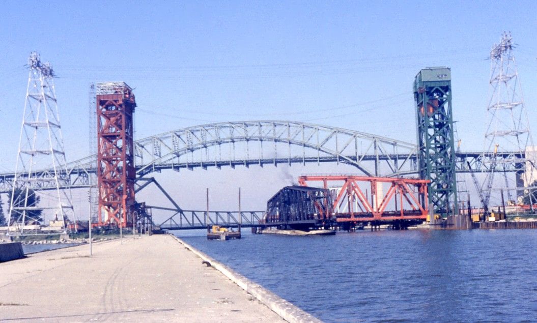
From Outlet to Canal

David O'Reilly

Registered User
Dec 15, 2012
481
4
18
#82
scotto
06-26-2014, 10:50 PM
“I have found a little more information on the building of the piers in a book by Marjorie Freeman Campbell, the book is named A Mountain and a City
__________________________________________________ ________

Maps also indicate the rapid development of the town. In 1830 a Hamilton map by Lewis Burwell shows a hundred acres surveyed. Six years later one by Alexander Mackenzie shows eight hundred acres.
This increase in population and extension of boundaries was due largely to the building of the Burlington Bay canal. On March 19th, 1823, an act of parliament authorized construction of a navigable waterway to replace the shallow natural outlet which provided passage only for small schooners and the flat bottomed batteaux used widely at that time in the carrying trade. With larger vessels, cargo was unloaded on the Lake Ontario side of Burlington Beach and trans-shipped. The new canal was built in its present location, south of the natural inlet which was later filled in.
Although reports show a "drudge" was used in construction of the canal, the work was done mainly by hand with pick and shovel and required an army of labourers. From far and near workmen flocked in, many bringing their own wagons, teams and tools. Hamilton became their headquarters and to accommodate them, dwellings, storehouses, barns and wharves sprang up along the bay shore—unpretentious frame homes mostly, with a sprinkling of better class residences. In the resultant boom, land and water lots were at a premium, capital was attracted, and wharf building flourished.
Simultaneously receiving attention was the project of Pierre (Peter) Desjardin7 to cut Coote's Paradise by a canal which would permit ships entering Burlington Bay to proceed by the natural navigation route— across the bay and north of the present Valley Inn—into the marsh and by canal to Dundas. On November 1st, 1820, Desjardin's petition for land and water rights was granted. Not until January 30th, 1826, however was the Desjardins Canal Company (capital, £10,000) incorporated to construct a canal three to four miles in length, including natural naviga¬tion within the marsh. Unfortunately Peter Desjardin did not see his dream realized. His death on September 7th, 1827, postponed the opening of the canal for another decade.
Simultaneously John Gait, founder of the Canada Land Company, after whose family Gait, Ontario, is named, determined to profit in the new mercantile era. Applying for land adjacent to the Burlington canal, Gait planned to establish a depot where immigrants and cargo might be unloaded and forwarded overland to Guelph and other hinterland points. His plan was confounded by the impossible roads of the day.
In the meantime the Burlington canal had gone its own way. In 1829 Hamilton's first steamer, the John By, a barge equipped with engines and paddles and drawing only two and one-half feet of water, is reported as running between Hamilton and Toronto, taking a day and night for the trip. In keeping with the times her first cargo was whiskey.
Accounts of the canal are conflicting but pieced together provide a fairly accurate overall story. "The Burlington canal," wrote George E. Mason, "was commenced in 1823 and completed in 1826 by Captain John McKeen and James G. Strowbridge, both of whom are buried at the southeast corner of King and Wellington Streets.9 The width of the canal was originally only 30 feet. Prior to the digging of this canal Ancaster . . . (had) in 1818 twenty prosperous stores; but many of her most enterprising business people, such as Edward Jackson, Richard and Samuel Hatt, &&, removed to Hamilton on the opening of the canal."
Contractors of the canal we find listed as Spohn & Mann; while Inspector J. H. Smith, county historian, gives the complete cost of the project as $94,000.
By an act, dated February 17th, 1827, the provincial legislature provided for a survey of works at the Burlington canal and further aid to complete the same. Autumn and spring gales and winter ice undoubtedly took heavy toll of the channel. In a report submitted in the autumn of 1828 to the canal commissioners—William Chisholm, William Applegarth and John Aikman—William Johnson Kerr, superintendent, gives a graphic picture of canal renovation of that day with the tools available.
I ... put the Drudging Machine in repair, and commenced deepening the Canal about the l0th May . . . and by the l0th June I discontinued the Drudge, having a depth of water averaging twelve feet through.
I then began repairing the South Pier which was in a very Shattered State—I carried it out 800 feet upon the foundation laid by Mr. Hall (first superintendent) 200 feet of it had been washed away six feet below the surface of the water and the other 600 feet I took down principally to the water level—which I have tied with timber of one foot square fastened with two inch treenails 22 inches long.
The whole 800 feet are perfectly filled with heavy stones, 700 feet of this pier I have decked over with 2 and 3 inch plank, crossing the top ties at every four feet—well spiked with seven inch spikes—with heavy oak gunwales on both sides . . . secured with treenails and iron bolts, 22 and 18 inches long. To protect the foundation of the pier 40 cords of larger boulders from the Islands below Kingston were deposited on the south side, thus giving the ground swell an easier ascent upon the pier. The north pier was similarly repaired and 100 feet that had been washed away renewed.
In concluding, the superintendent suggested the need of bridging the canal after navigation closed, for the convenience of travellers and because of the expense of the ferry, which cost five pounds per month in wages to the ferryman who attended "late and early as well as on Sunday." That the suggestion bore fruit seems proved by an item which appeared in the Gore Balance, Vol. 1, 45, October 1, 1830: "The Swing Bridge over the Burlington Bay Canal will be opened October 2, 1830."”

Scott, does the author provide a reference for the information about the boulders having come from an island near Kingston? ‘Kingston’ is quite a distence to haul stone, given that the Niagara Escarpment, is right here, and stone was being gathered by stone hookers in the area.

Perhaps the stone was from the Kingston area. but it hadn’t been brought for the purpose of the Burlington Canal construction. But rather was used as ballist.

Sailing ballast is ballast is used in sailboats to provide moment to resist the lateral forces on the sail. Insufficiently ballasted boats will tend to tip, or heel, excessively in high winds. Too much heel may result in the boat capsizing. If a sailing vessel should need to voyage without cargo then ballast of little or no value would be loaded to keep the vessel upright. Some or all of this ballast would then be discarded when cargo was loaded.

https://en.wikipedia.org/wiki/Ballast#History
 

scotto

Administrator
Staff member
Feb 15, 2004
6,985
218
63
The Beach Strip
#83
scotto
06-26-2014, 10:50 PM
“I have found a little more information on the building of the piers in a book by Marjorie Freeman Campbell, the book is named A Mountain and a City
Scott, does the author provide a reference for the information about the boulders having come from an island near Kingston? ‘Kingston’ is quite a distence to haul stone, given that the Niagara Escarpment, is right here, and stone was being gathered by stone hookers in the area.

Perhaps the stone was from the Kingston area. but it hadn’t been brought for the purpose of the Burlington Canal construction. But rather was used as ballist.

Sailing ballast is ballast is used in sailboats to provide moment to resist the lateral forces on the sail. Insufficiently ballasted boats will tend to tip, or heel, excessively in high winds. Too much heel may result in the boat capsizing. If a sailing vessel should need to voyage without cargo then ballast of little or no value would be loaded to keep the vessel upright. Some or all of this ballast would then be discarded when cargo was loaded.

https://en.wikipedia.org/wiki/Ballast#History
I recall reading about a temporary rail line built to bring stone to the Beach from escarpment, horses were used to bring the cars back and gravity mostly was used on the return trip. Once that rail line was no longer in use, it could of been easier just to ship stone in.
 

scotto

Administrator
Staff member
Feb 15, 2004
6,985
218
63
The Beach Strip
#84
World's shortest ferry crossing?

found on google earth in Lanark Co. and sent in by Peggy.

North of Belleville, just east of Elgin in NE point of Indian Lake. I know the song but I never knew where it was.


Self-serve car ferry across the Rideau Canal to Scott Island. It pulls itself across by cables which also steer it. Owned by the Township of Rideau Lakes. It is a 35 m. crossing, the Toronto Island Airport is 121 m. crossing. After 3 years, and over 2,000 views, no one has challenged the claim of it being the shortest ferry anywhere. If the ferry is 10 m. long, and only travels 25 m, is it a 25 m. or 35 m. crossing?
 

Attachments

scotto

Administrator
Staff member
Feb 15, 2004
6,985
218
63
The Beach Strip
#85
Sent in by David;

(notice the name of the road)

FROM RICHARD HATT TO WILLIAM HALTON

Ancaster, 21 May,1811.

Sir,

I received your Letter of the 17th Ulto., acquainting me of the appointment which

it has pleased His Excellency to honor me with, and in order to carry the same into effect

as soon as possible (being unable at this time to leave my family) I have taken the liberty

to empower my Brother to receive such part of the many appropriated by the said Act, as

may more particularly fall under my immediate inspection to lay out, that is from

Vanderlip to A. Westbrook's from Brady's Tavern tho' Saltfleet to the Forty Mile Creek,

on the New Lake Road; and building a Bridge over the Outlet at Burlington Bay, which is

the arrangement lately made with the other commissioners.

I have the honor to be &c.

RICHARD HATT

Major W.Halton.

(Sundries, Upper Canada, 1811.)


Whole publication;
http://webcache.googleusercontent.c...um/media/NHS42.pdf+&cd=12&hl=en&ct=clnk&gl=ca
 

David O'Reilly

Registered User
Dec 15, 2012
481
4
18
#86
Drogo
11-09-2013, 03:03 PM
Appeared in the Spectator Jan. 28, 1881

THE BURLINGTON CANAL

Incidents Attending Its Construction
(Written for the Spectator)

The building of the Burlington Canal was a big event, and the inquisitive inhabitants for many miles round about, as curiosity or Business called them, did not lose an opportunity of watching the progress of the work. Small spritsail boats and bateaux had passed occasionally through the natural outlet from the bay, when the mouth was not closed up with sand by easterly storms: but when an artificial passage through the beach was contemplated it was considered the eighth wonder of the world. How was it possible for so great a work to be accomplished? How was the drifting sand to be kept in check, or how could it be dug out? At all small gatherings of the people-at bees and visiting parties the subject was discussed; neighbourhood dispute and gossip were forgotten in the presence of this great enterprise; the general opinion being that it must end in disappointment. Why, the beach was all sand, the accumulation of the and blown material brought thither by easterly storms during centuries past, which, being deposited at first as a bar, had in the end risen above the surface; and as no westerly blows could disturb it, or carry it away, the result was the present ever widening beach.

The simple inhabitants were greatly exercised over the magnitude of this wild project; they had seen again and again the pent-up waters of the bay rise above the level of the lake, and sweep away the great sandbars at the outlet; and again they had seen the bellowing, raging, east storms heap immense banks of sand across its mouth, and stop the flow of what, only a few days before, was a great river; therefore, how was it possible to construct a work capable of resisting these mighty forces and secure a channel always open to admit the passage of vessels? To attempt such a thing seemed as chimevical (unreadable ?) as King Canute’s attempt to check the flow of the tide. Notwithstanding, there were a few great men scattered about, among the people in those days, who appeared to think otherwise- men who had seen Montreal, once at least, and York (Toronto) many times. They were not like the modest, vote-seeking great men of today-but bold, outspoken men, confident; men who swelled out their bosoms like poater (?) pigeons, and hoarsely cleaned out their throats before speaking, and deposited the contents in their pocket kerchiefs, and spreading wide their feet, delivered their borrowed opinions to the gaping listeners-stopping occasionally to snort loudly through their noses, by way of confirming the importance, and the undying correctness of their opinions. They, with heads as empty as bellows, had the honor of an introduction to certain great engineers in Montreal, and they had said, “The projected plan for cutting through the Beach and securing an uninterrupted passage for vessels was practical.” This was final, no further information was necessary. Happy day when the masses pinned their faith in all things to the sleeves of those above them.

I’ve found some information about an Abel Land who owned a forwarding business in Hamilton , and operated a bateaux through the natural outlet.

“He built a wharf at the Bay front on his lot east of Wellington Street. It was approached by a road called Land's Lane, which skirted the east side of a long inlet. Besides farming he carried on a shipping and forwarding business, dealing in commodities such as salt, whiskey, potash, grain and flour from his wharf at the foot of Wellington Street, using heavy pioneer boats called bateaux which passed through the Bay's natural outlet to Lake Ontario, for the canal was not built until 1832.

http://boards.ancestry.ca/surnames.land/1082.2.2.1/mb.ashx

and I’m still looking for information about any wharves that were built on the lake side of the beach , to acommidate the schooners that brought the goods headed for Hamilton.
 

David O'Reilly

Registered User
Dec 15, 2012
481
4
18
#87
Here is some information that was written by a Richard Henry Bonnycastle, that alludes to a railroad that was built to transport stone from the Niagara Escarpment, to be placed in the piers alongside the canal.

“That which I wished particularly, however, to see, was now close to us, the Canal into Burlington Bay.

Burlington Bay is a little lake of itself, surrounded by high land in the richest portion of Canada, and completely enclosed by a bar of broad sand and alluvial matter, which runs across its entrance. In driving along this belt, you are much reminded of England: the oaks stand park-like wide asunder, and here, on tall blasted trees, you may frequently see the bald eagle sitting as if asleep, but really watching when he can rob the fish-hawk of the fruits of his piscatory toils.

The bald eagle is a cunning, bold, bad bird, and does not inspire one with the respect which his European congeners, the golden or the brown eagle, do. He is the vulture of North America rather than the king of birds. Why did Franklin,[1] or whoever else did the deed, make him the national emblem of power? He is decidedly a mauvais sujet.

[Footnote 1: I think, however, I have read that the philosophic printer gave him a very bad character.]

The Canal of Burlington Bay is an arduous and very expensive undertaking. The opening from Lake Ontario was formerly liable to great changes and fluctuations, and the provincial work, originally undertaken to fix the entrance more permanently, was soon found inadequate to the rapid commercial undertakings of the country. Accordingly, a very large sum was granted by the Parliament for rendering it stable and increasing the width, which is now 180 feet, between substantial parallel piers.

There is a lighthouse at each end on the left side going in, but the work still requires a good deal of dredging, and the steamboat, although passing slowly and steadily, made a very great surge. In fact, it requires good steerage-way and a careful hand at the helm in rough weather.

The contractors made a railroad for five miles to the mountain, to fetch the stone for filling-in the piers.”

http://www.hotfreebooks.com/book/Canada-and-the-Canadians-Vol-2-Richard-Henry-Bonnycastle.html
 

scotto

Administrator
Staff member
Feb 15, 2004
6,985
218
63
The Beach Strip
#88
Sent in by David
_____________________________
From the report;
Annual Report of the Department of Railways and Canals

https://books.google.ca/books?id=zCY0AQAAMAAJ&q=burlington#v=snippet&q=burlington&f=false

BURLINGTON BAY CANAL
Length of Canal 1/2 mile
No locks on this canal
Average breadth Between 138 feet
Least 108
This canal is cut through the sand bar which separates Burlington Bay from Lake Ontario and is navigable for vessels drawing ten feet of water. It Gives access to the port of Hamilton and to the Town of Dundas vid the Desjardins Canal The canal was closed on the 16th December 187 in September and re opened on the 1st April 1880

All Necessary repairs have been executed. The works placed under contract for the reconstruction of the north west pier destroyed by fire and for rebuilding a portion of the pier on the opposite side are progressing in a satisfactory manner App 9 Page 163


BURLINGTON BAY CANAL
SUPERINTENDENT'S OFFICE
ST CATHARINES 24th September 1880
SIR I have the honour here with to transmit my report of the working and condition of the Burlington Bay Canal for the year ended 30th June 1880.
The canal was closed on the 16th day of December and opened on the 1st day of April’
The number of vessels that have passed through this channel has increased during the last season.
The channel piers are now being used by a great many steamers as a landing lace for the large numbers of pleasure seekers that they convey to the rapidly increasing popular resort known as Burlington Beach.
The reconstruction of the pier that was burnt two years since, and the removal and rebuilding of the other rotten pier on the opposite side of the canal was commenced in February last and is proceeding satisfactorily.
Next year the remaining portion of the south east pier will require to be rebuilt and the balance of the north west pier the following year.
No accident or damage of any consequence has occurred to the works throughout the season.
The traffic across the ferry has at this place increased immensely within a recent period and some other mode of propulsion besides manual labour for the ferry scow will probably become necessary very soon.
The stone filling washed out entirely in many parts of the cribbing I Have had recently filled up.
I have found it necessary to do some repairs to the Ferryman's house and outhouses. The other repairs have been very light.
I have the honour to be Sir,
Your obedient servant;
WILLIAM ELLIS
Superintendent.

Secretary,
Department Railways and Canals.
Ottawa
 

scotto

Administrator
Staff member
Feb 15, 2004
6,985
218
63
The Beach Strip
#89
The Monthly Review: Devoted to the Civil Government of Canada, Volume 1

Sent in by David
____________________________
https://books.google.ca/books?id=948eAQAAMAAJ&pg=PA394&source=gbs_toc_r&cad=3#v=onepage&q&f=false
Report of a Survey of the Burlington Bay Canal, with plans and estimates for repairing the same, together with plans and estimates for a new Canal made for the information of His Excellency the Governor General.
In pursuance of instructions furnished me, I have carefully inspected the above work and beg leave to accompany my report with a drawing of the Canal in Its present state, which will show generally its condition depth of water site &c. This report is also accompanied by a chart of the head of Lake Ontario with a sketch of the site of the present Canal, together with that of the one contemplated. It is impossible by any drawing to exhibit the state of ruin of the present Canal. On entering it from Lake Ontario, to the south are the remains of an intended break water, originally several hundred feet in extent from nearly north to south, and once partially loaded with stone, the whole of which is overthrown and washed away, except the piles, which are exceedingly dangerous to the navigation, more especially in attempting to enter the Canal in the night or during heavy storms. The extreme end of the south pier is also washed away, except the piles, which add in no inconsiderable degree to the danger of the navigation. A portion of the south pier adjoining was removed by the late gale, and no dependence can be placed upon its resisting the next storm which arises. (Since writing the above, the breach which had been made by the late gale you so much increased as to endanger vessels on entering the Canal, to which something should be immediately done. A second breach of sixty feet in extent has also been made within the last few days and it is impossible to say to what extent it may be carried during the winter.)
The remaining part of the south pier to the beach is the most substantial part of the work, having been better constructed and repaired only a few years ago. The south west pier has been removed from its original position nearly from one end of it to the other the bottom logs lying upon their sides caused in the first place by having been built upon the sand and undermined by the current but affected in a still more injurious manner by the pressure of the ice. The water between the piers in the Canal never freezes whilst the ice on the outsides is frequently from two to three feet in thickness, subject of course to its usual expansion and contraction. The current which is constantly passing either into or out of Burlington Bay, under the influence of the prevailing winds which it frequently does at the rate of four or even six miles an hour, necessarily carries away the sand from the bottom of the Canal, and partially from underneath the cribs which form the piers, producing a tendency in them to fall inwards, and the more so, because whilst the sand is washed away within the Canal it accumulates without it at the back of the pier. In addition to this, the pressure of the ice has been so great as to drive the piers bodily into the Canal, breaking off some and removing others of the piles, so much so that there is no foundation which can be relied on for making any efficient and permanent repair upon the present site.
The timbers of the north-west pier are most of them gone, and the greater portion of its entire length is about two feet under water. The north east pier is on the whole in the most efficient state but in a very short time will be in as bad condition as the other piers which form the Canal.
In the present state of the finances of the Province it is presumed that it would be thought advisable, if possible, at least for two or three years to keep the present Canal navigable without any large expenditure, and a close examination has been made with this object in view; the conclusion however is that the navigation of the Canal cannot be ensured for a single season, that the state of the piers is beyond any temporary repair and that any repair to be at all efficient would require an outlay of at least £25,000, and even then it is believed would not be durable, or available for the purposes for which the work was originally intended.
There appear, moreover, several reasons against expending so large a sum in repairing the present Canal. A very considerable portion of the sum required will be necessarily expended in taking up the old work which will prove to be a difficult as well as an expensive and tedious operation. The site of the present Canal too is now admitted by all persons who are acquainted with the navigation of Lake Ontario, to have been injudiciously selected. The depth of the Canal does not in some parts exceed eleven feet six inches, and it cannot safely be deepened, whilst the water is at present a foot deeper than it is at some seasons.
(Cont.)
 

scotto

Administrator
Staff member
Feb 15, 2004
6,985
218
63
The Beach Strip
#90
The width at the narrowest part (the bridge) is not sufficient to admit our largest class steamboats to pass through it. And beyond all other considerations, it is believed that the growing importance of Hamilton and its vicinity, more especially if the contemplated railroad from that place to the St Clair should be carried into operation, will require a Canal between Lake Ontario and Burlington Bay far more capacious and commodious than the present one is, or can be made by any repairs which can be effected.
The next object was to examine if a better site was not to be found as well as to ascertain what would be the cost of a Canal sufficiently commodious and which would be both substantial and durable.
An examination was first made of what has been generally considered the natural outlet, and which it was stated had on some occasions been sufficiently deep to allow small vessels to pass through it. The nature of the substrata was examined as well as the depth of water, and the relative distances into both the Bay and the Lake. Bearings were also accurately taken, and observations made of the effect of the winds during heavy gales from the north east, south east, and south, and a chart was drawn with these respective bearings laid down.
Enquiries were extensively made of Captains of steamboats, as well as sailing Captains navigating the Lake, and after the most minute investigation and deliberation, it was concluded that the nearer the Canal can be placed to the north shore, the better it will be, and for the following reasons.
A very cursory examination of the chart will show, that during strong north east, east or southerly gales, the waters of the Lake will be driven with great violence towards its termination upon the beach at Burlington where the swell is greatest as the water is less sheltered by the head lands and the north shore. Near the shore there is comparatively little swell, which increases with the distance from the shore. During northerly winds, the water near the shore is calm whereas a heavy sea is encountered even at the entrance of the present Canal. During southerly gales especially those from the south east, there is the greatest swell on the north shore, and wherever the site for the Canal is selected its direction must be so chosen as to promote still water with the wind from that quarter. Under all these circumstances the site and direction of the new Canal, as marked upon the chart, has been preferred. (The Hon John Macaulay, late President of a Board of Commissioners for improving the internal navigation of the Province, appointed in 1824, has since this report was written, obligingly favoured me with a copy of their proceedings which were conducted with great care and assiduity, and it is very satisfactory to be able to quote the opinion of that Board, confirmed by the Engineers employed by them at the time, which is to be found in their report in the following words; “In making choice of the situation for the Canal every proper consideration was given to the advantages and disadvantages of every part of the beach, and after comparing them it was the decided opinion of the Civil Engineer, in which opinion the Marine Surveyor concurred, that immediately under the high bank near Mr Brant's, was the most favourable point for the work.”)
It however, became necessary, before determining, to ascertain the practicability of the site selected and to examine the substrata other localities. And this was the more necessary, because had been reported by former surveys that rock formation extended from the shore to this spot, and the rock was stated to be within about six feet of the surface. Soundings again accurately made both on the Lake on the Bay and no rock could be found boring with a rod 20 feet in length below surface of the water and it seems highly improbable that a formation of rock should existed so near the surface on a narrow of beach which had evidently been formed the waters of the Lake, and which does not 100 yards in breadth.
It appeared probable that an accumulation of stones which had been washed up from Lake, the number of which evidently in a direction towards the angle of the Lake, and which it would be very difficult for a boring machine to penetrate had been mistaken for rock formation. This opinion derived confirmation from name given to this part of the beach by the which was stated to me by Mr. Kerr, Succussinekong, an accumulation of stones, they translate it. A rod was with difficulty, however, forced down upwards of twenty through the beach, as well as in several parts on the margin of Brant's Pond, a little further north as well as south, with the result.
In order, however, to remove all doubt upon a point so important to the future progress the work, it was determined to sink a shaft through the beach, more especially it was found impossible from the nature of sand to bring up with the borer any of the soil into which it last penetrated. A Kurb provided, and the result has proved that a Canal may be formed at any part of the beach south of where these trials were made, and it is believed, that if it were desirable it may also effected still farther north.
(Cont.)
 

scotto

Administrator
Staff member
Feb 15, 2004
6,985
218
63
The Beach Strip
#91
There is good reason for believing that outlet by which the waters that run into Burlington Bay have discharged themselves, has been formerly to the north of where the shaft was sunk, and it has been probably very near the cliff, through what is now called Brant's Pond. It is believed that an accumulation stones having been thrown up into the channel during the prevalence of strong gales from the south east, which the press of the water unable to remove, it rose in consequence its usual level in the Bay, and found its way over that part of the beach which, being composed principally of sand, could be more easily displaced. It is worthy of remark that so soon as the Canal was opened this channel immediately filled.
Soundings in that direction having been carefully taken, distances ascertained, and the bearings of the different head lands laid down, the place recommended was selected as on the whole best site for the Canal, and it is believed it will prove to be as was stated by a very intelligent sailing Captain whose opinion asked, a blessing to persons who like had been exposed to the dangers and difficulties arising out of the want of a safe harbour at head of Lake Ontario, as well as of the approaching present Canal in stormy weather.
It will be seen by a reference to the chart that a harbour of this description will be formed inside the piers of the Canal, where there is best anchorage, and where vessels may ride safety during the heaviest gales from whatever quarter they may blow. The next consideration which presented was the nature of the construction of intended Canal. Whatever that construction might be, it is obvious from the preceding observation that it must rest upon a foundation different from that upon which the piers of present Canal stood. The foundation must through the sand, and if possible rest on blue clay formation which is to be found beneath it, and if built of solid masonry, must probably even then be supported on piles.
The instability of the present structure has arisen from the piers having been sunk on the sand, without dredging so as to reach the blue clay which is to be found at about 21 feet deep, and the inferiority of the workmanship has no small degree contributed to it.
Had the bottom been dredged so as to (?) cribbs might have rested below the water the Canal, and had the workmanship been of character and able to resist the force with which it had to contend, it is presumed that the Canal might have answered the purpose many years to come. It will be found practicable to construct the new Canal upon similar principles, remedying the above defects, and the part out of water may be covered either solid masonry or with timber well framed and filled with grouting, and covered with a substantial sea pavement.
It is submitted that there are four modes of construction which present themselves. First, by excavation through the beach to the required depth, forming the banks of the natural soil, with a slope of about 30 degrees. Second, by the formation of coffer dams formed by close and deep piling, filled in with well puddled clay and stone, so as to be impervious to the wash of the water. Third, by solid masonry at both entrances, and coffer dams between the intermediate distances. Fourth, by solid masonry for the whole. Estimates with sketches of each of these methods are annexed.
The first method which is by far the cheapest, is liable to many objections. The water at the sides of the Canal will be necessarily shallow, and notwithstanding the slope is so gradual, the action of the current, aided by the natural swell as well as that produced by the paddles of the steamboats, will render constant dredging necessary. Eddies will be formed by the prevailing winds, and the channels at both entrances will, it is believed, be shifting and of course difficult to discover.
The formation of suitable coffer dams will be an efficient and permanent structure, if the piles are well driven into the blue clay and close together, aided by sheathing so as to prevent the material with which they are filled from escaping, capped with a strong and well executed frame work, mortised down upon the top the piles, well braced with cross ties and the whole to be below the low water mark. The superstructure out of the water may be formed of framed timber, filled with stone, and covered with a good sea pavement laid in water lime, which can be easily repaired when necessary, without disturbing the foundation, which it is believed will be very durable; these coffer dams may be made accessory to the erection piers of solid masonry at some future period, and would be so much in aid thereof.
The third plan, or that of solid masonry for the two entrances, and coffer dams, formed either of cribs or by piling, will be perhaps the most to be recommended.
The fourth, or a structure of solid masonry, is the mode by which works of a similar description have been erected in Great Britain, and although it would be attended with some difficulty in its construction, is nevertheless very practicable and would last for ages. Stone of an excellent description is to be obtained suitable for it both on the Lake shore at Hamilton and in the mountain within three miles of the place, where it is inexhaustible, and is of the finest quality.
Estimates of the cost of each of the above structures have been carefully made, and are appended to this report. It has been considered that this report should state what the probable income arising from Canal and Lighthouse will be to enable his Excellency to judge of the return likely to made for the sum expended. It is satisfactory to be able to state, that with a due regard to the collection, there is every reason to believe that a revenue will be realized sufficient to discharge the interest of the required for the completion of a permanent structure, and it is also believed that it will become capable of gradually lessening and ultimately of discharging the principal.
(Cont.)
 

scotto

Administrator
Staff member
Feb 15, 2004
6,985
218
63
The Beach Strip
#92
Cont.
In the year 1835-6 the tolls amounted about £1900; for some reason not ascertained about that time the rate of tollage was greatly reduced, and since then the amount collected has fluctuated greatly. It seems to be generally admitted that tolls require to be remodelled, and it is asserted that they are capable of being made to produce £4000 per annum without being high to any class of the community. It is also observable, that although the public have the accommodation of a bridge in passing across the beach, by which a distance of 12 miles is saved if persons travelling were obliged go round by Hamilton, no toll is charged. It is believed that if a moderate toll was collected it would produce a revenue of £500 per annum from which no deduction would be for collection, as the same person who attends the bridge and the light house would also collect the tolls. Nor could any reasonable complaint be by the public against paying a moderate toll for the use of a safe and commodious bridge, because before the Canal was cut the passage across the beach at the outlet was frequently dangerous and sometimes impracticable, and various accidents are stated to have occurred.
It may perhaps be desirable to expend a sum of about £300 in improving the beach road, in which case it is presumed the public would not only be greatly benefited but fully satisfied. Estimates are then given of the cost of each of the four methods named, the first is estimated at £6500 the second including bridge and light houses at £33,975 2s 6d the third also with bridge and light houses at £45,000 the fourth with bridge and light houses at £88,492. An estimate is also made for a breakwater 300 feet long which would cost £1500.
 

scotto

Administrator
Staff member
Feb 15, 2004
6,985
218
63
The Beach Strip
#93
Sessional papers

VOLUME 8
FIRST SESSION OF THE NINTH PARLIAMENT
DOMINION OF CANADA
SESSION" 1.901
From the Toronto Public Library

BURLINGTON CHANNEL.
Burlington Channel, in the county of Wentworth, is simply a cut through a piece of low laud which partly separates Lake Ontario from a large sheet of deep water called Burlington Bay, enabling vessels to reach the wharfs at the city of Hamilton. Both sides of the canal are lined with piers.
Construction.—The work was commenced under commissioners in 1825. It was opened for the passage of vessels in 1830, and completed as originally undertaken in 1832, at a cost $124,356.08. The works were afterwards extended, improved and partly reconstructed by the provincial government at an outlay of $308,328.32. previous to Confederation. From 1867 to 1882, inclusively, the superstructure of the piers having been partly destroyed by fire, was renewed by the Government at a cost of $30,426.89. It was maintained by the Railways and
Canals Department till 1S85, when it was placed under the control of the Department of Public Works. The general form of the canal has not since been changed, and consists of a cut through a sand bar about 2,700 ft. in length, with an average depth of 14 feet at low water, both sides of the cut being lined with vertical-faced cribwork piers. The northern pier has a total length of 2,307 feet and a general width of 20 feet, excepting at the outer and inner ends where there are blocks 30 and 35 feet wide. The southern pier has a total length of2,710 feet and a general width of 20 feet, excepting at the outer end where there is a cribwork block of 30 feet wide for a distance of 30 feet, and at the inner end, where the cribwork is of irregular form and the width, varies from 25 to 45 feet for a distance of 590 feet. The piers are 103 feet apart at their inner ends and 174 at their outer ends. The top of the piers is 5' feet above ordinary low water.
The southern pier carries a lighthouse ; above the centre of the piers, at the crest line of the sand bank, recesses were left in the cribwork on both sides for a ferry scow running across the channel. There is also a traffic swing bridge built by the Dominion Government close to the railway bridge opening on the south side.
In 1895 the traffic over the channel had increased to such an extent that it was found impossible to accommodate the public, and this department prepared plans and specifications for the erection of an iron swing bridge. The contract for the masonry of this bridge was let to Mr. Geo. F. Webb, of Hamilton, in August, 1895 for the bulk sum of $15,799. The masonry work was completed ready for the iron superstructure, in April, 1896. On January 28, 1896, another contract was awarded to the Dominion Bridge Co., of Montreal, for supplying and erecting
the iron superstructure, .Sic, for the sum of $15,290. All the works in these contracts have been satisfactorily completed. A further sum of $1,500 was paid to the Dominion Bridge Co. for supplying and installing, by special agreement, an electric apparatus for operating the swing span ; power is supplied by the Hamilton Electric Radial Railway Company.
In 1897-8 automatic gates to regulate the traffic at the approaches have been erected. Telephone communication has been made with the ' power house ' and a ' power indicator,' for the information of the man in charge, has been placed in the bridge house. Extensive repairs were also made to the piers, which consisted in placing new faced timbers, some planking and earth filling. The whole of the repair: were completed at the beginning of the fiscal year 1899 and the sum of $1,366.75 expended.
During the past fiscal year the wages of the working staff of the bridge, and maintenance, amounted to $2,662.00. Repairs to bridge, etc., $1,312.91.
Tenders were called for the reconstruction of the superstructure of the south pier, western or bay end, a distance of 989 feet from low water level up and the construction of sheet-pile work on the channel side. Work on this contract had not commenced at the end of the fiscal year.
 

scotto

Administrator
Staff member
Feb 15, 2004
6,985
218
63
The Beach Strip
#94
From Ray Mifflin's book, Harbour Lights-Burlington Bay
Added at the request of member David;


Seven gales struck the beach from the time tolls were first collected in 1828 until the end of 1832, but it was a late October gale in 1831 which impressed upon the residents at the head of the lake that a proper lighthouse was still very necessary.
The schooner Commerce, from Oswego, New York was driven aground on Burlington Beach opposite the farm of William Lottridge with a full cargo of salt and merchandise belonging to merchants of Hamilton and Dundas. The salt and merchandise were totally destroyed. Cries for a lighthouse to mark the treacherous entrance to the piers were voiced by Captain Lucas and area residents. These cries were repeated in 1836 when the schooner Elizabeth went ashore on the north shore of the lake and had to be pulled off by the steamer Gildersleeve and towed to the canal. Rumours that "wreckers" were using false lights on the beach to lure vessels aground made the construction of a lighthouse of vital importance.
It was not until 1837 that a 54-foot wooden lighthouse (from base to vane) was finally built at canal by John L. Williams, an American.
It was a frame octagonal-shaped structure, clapboarded, and set on a stone foundation. It was similar in design to the main lighthouse at Port Dalhousie.
During 1837 £12 19s was collected in lighthouse duties from vessel owners to help pay for its construction and maintenance. The lighthouse burned 213 gallons of whale oil annually, required 12 dozen wicks for its Argand lamps, 20 pounds of soap to clean its windows, 2 chamois skins to polish its reflectors and 10 pounds of whiting for painting its exterior.
John Chisholm, Collector of Customs, appointed William Nicholson as the keeper of the new lighthouse. He lived in the residence of the former dredge operator, McAfee. who died of cholera in 1832. The new lighthouse could be seen 15 miles onto the lake.
 

scotto

Administrator
Staff member
Feb 15, 2004
6,985
218
63
The Beach Strip
#95
Of the Commissioners on Bay Canal

Sent in by David

To His Excellency Sir Francis Bond Head Lieutenant Governor of the Province Upper Canada & c & c & c
MAY IT PLEASE YOUR Excellency The Commissioners for the Burlington Bay beg leave most respectfully to Report on the state of the work entrusted to their care The Commissioners had the honor of your Excellency on the 8th of July last on that state and that the immediate repairs being made to the South Pier Lake Ontario with the view of saving so a channel from total destruction Upon which Your Excellency with the advice of the Honorable the Executive Council was the sum of £750 from the Crown funds the necessary repairs of the Burlington Bay which repairs have been made The Commissioners have the honor of having an account of expenditures in the repairs estimated for amounting to £671 5s 10 d having a balance in their hands of £78 14s 13 d The Commissioners conceive the following pairs and alterations necessary to the safety of the Canal which when completed will tend much to the convenience and ease of schooners and steamers entering the same viz. The removing a part of the North Pier in Lake Ontario Narrowing or contracting the Channel of the Canada to more uniform width. Extending the North Pier farther out into Lake Ontario with a wider entrance from the same. Constructing a Pier on the South side. Making more substantial Butments to the Swing Bridge. A Light House on the Beach with revolving lights and better lamps on the extremity of the piers. To effect the alterations and improvements abovementioned it will require the sum of £4500 which the Commissioners will be Your Excellency will be leased to the attention of the Legislature All of which is most respectfully submitted By Your Excellency's Most humble servants Signed
W CHISHOLM 44
WM APPLEGARTH
December 7 1836

https://books.google.ca/books?id=UI...ed_pages&cad=2#v=onepage&q=burlington&f=false
 

scotto

Administrator
Staff member
Feb 15, 2004
6,985
218
63
The Beach Strip
#96
Another small addition;
Wayne Sentinel (Palmyra, NY), 12 May 1824

The Burlington Canal. - The Commissioners of the Burlington Canal, have given notice that they are ready to receive proposals for making a cut from Burlington Bay to Lake Ontario, 12 feet deep by 72 feet wide. The Lewiston Sentinel says this will be sufficiently large to admit sloops of war, and will afford the Canadians most decidedly the finest harbor on Lake Ontario; its advantages to the Province at large will be great; but to the immediate vicinity of the head of he Lake it will be incalculable. Indeed, those who are acquainted with the natural situation of Burlington Bay, or the Little Lake, as it is called, will only be surprised that this work, which can be accomplished at so trifling an expense, and afford such vast advantages to Upper Canada, was not long since executed.

http://images.maritimehistoryofthegreatlakes.ca/63038/data?n=10
 

scotto

Administrator
Staff member
Feb 15, 2004
6,985
218
63
The Beach Strip
#97
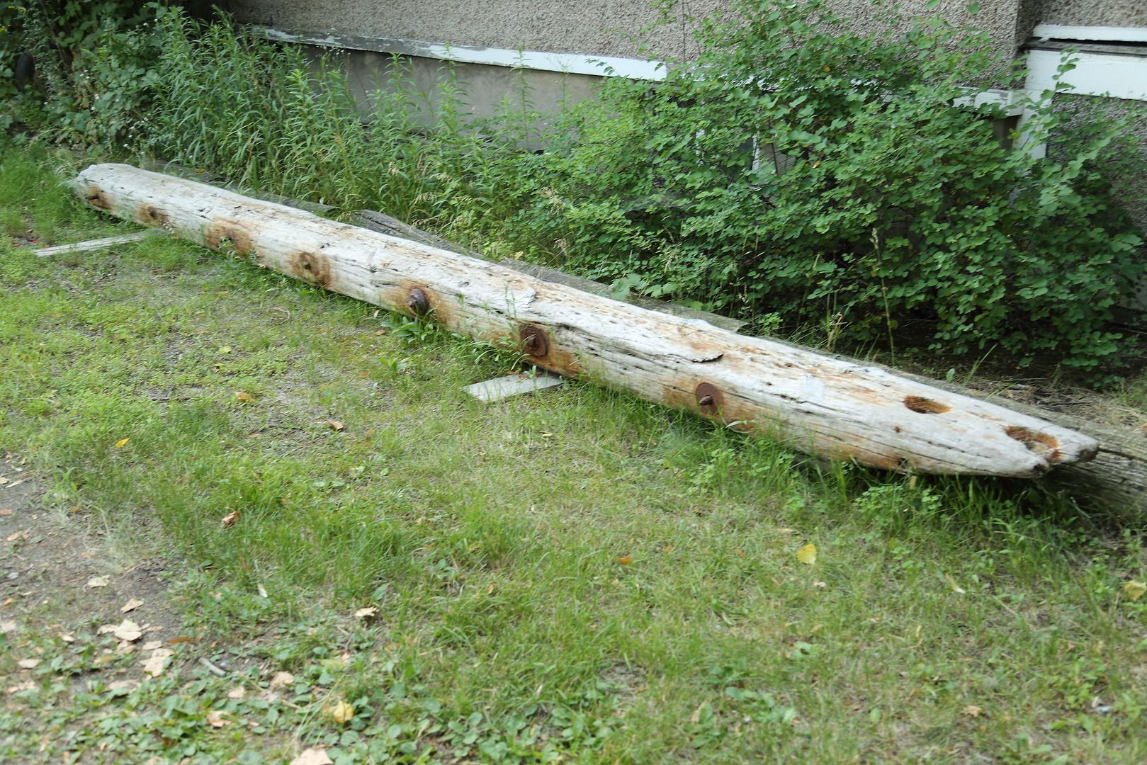
I noticed the piece of lumber on a Beach resident's property a while back and thought that it could be from our canal's piers.


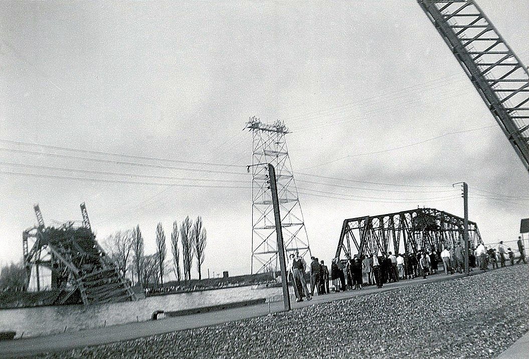
Looking through some photos I noticed this picture (sent in by member Crawfish) taken the day after the W.E. Fitzgerald hit the north bascule bridge and destroyed it. This picture would be dated April 29th, 1952.
Check the edge of the of the where the onlookers are and the wooden rails with two missing, they are cut on an angle as is the one above.
Crawford Collection


Another photo from about mid 1961, the rail is still attached to the pier.
Courtesy T. Egan
 

scotto

Administrator
Staff member
Feb 15, 2004
6,985
218
63
The Beach Strip
#98
https://www.erudit.org/en/journals/onhistory/2018-v110-n1-onhistory03559/1044326ar.pdf
Building the Burlington Bay Canal
The Staples Thesis and Harbour Development in Upper Canada, 1823-1854
by Rod Millard


The Burlington Bay Canal was built to provide a harbour at the head of Lake Ontario. Designed in 1824 by a British engineer and constructed by an American contractor, the canal cut across Burlington Beach, a long narrow sandbar separating Lake Ontario from Burlington Bay, (renamed Hamilton Harbour in 1919), to form an entrance to a natural harbour. It was Upper Canada’s first government -financed internal improvement, and an important factor in the rise of Hamilton. Together with other lower Great Lakes harbours, the Burlington Bay Canal was an essential part of the Great Lakes-St. Lawrence transportation system during the pre-railway era. By 1959, the canal gave Hamilton access to the St. Lawrence Seaway, the world’s longest navigable inland water-way. During its construction in the 1820s and ‘30s, however, the Burlington Bay Canal was an engineering, financial, and political fiasco. It collapsed several times, cost more than expected, and generated political controversy.


1557778251128.png

https://en.wikipedia.org/wiki/Staples_thesis
 

scotto

Administrator
Staff member
Feb 15, 2004
6,985
218
63
The Beach Strip
#99
Picked up a post card showing how the cribs were constructed at one point in time with gaps between each crib and the planking on top joining them together. I haven't see this construction in any other pictures but keep in mind, as written in this thread, the piers were destroyed many times by Lake Ontario and rebuilt.
As for a year, I have seen this same post card on another site postmarked November 1906.

HBCF Collection
Three Children.jpg
 

scotto

Administrator
Staff member
Feb 15, 2004
6,985
218
63
The Beach Strip
Checked through my old pictures and can only come up with a picture from the same photographer, very hard see if there are gaps between the cribs in the photo though. One explanation is that the children picture was taken on the harbour side therefore needing less support as the Modjeska photo is clearly taken the lake side.
Notice the bottom right signature, "Thompson Photo Post Card"

Mojeska.jpg


Edit;
In Dorothy Turcotte's book, Burlington, The Growing Years, there is a picture of Baxter's Wharf located at the bottom of Brant Street. The pier is identical to one with three children on it shown above. So the pier was in Burlington, just not on the Beach.
Baxter'sWharf.jpg

Another angle during the winter with the Beach in the background.
BurWharf1.jpg
 
Last edited:
Top Bottom