Interesting link to old map of Saltfleet Twsp

scotto

Administrator
Staff member
Feb 15, 2004
6,985
218
63
The Beach Strip
#4
Bobby;
I found one of them which shows many of the sidestreets, I don't think it goes as far as Dunraven though, I will have another look. The one other I had access to show all the land around Dynes, I have attached it but it's a little blury. I will see if I can get it back and make a better copy.
Scotto
 

Attachments

scotto

Administrator
Staff member
Feb 15, 2004
6,985
218
63
The Beach Strip
#5
Kenmore Park Survey

This one from 1911, only shows six sidestreets and doesn't go as far as Dunraven, there must be others that show the whole Beach. I will have to take a trip to the library and see what they have.
Notice the name change on four of the sidestreets, most likely happened when the Beach left Saltfleet and joined Hamilton. Thanks to T. Lytwin for sending this map in.
Scotto
 

Attachments

scotto

Administrator
Staff member
Feb 15, 2004
6,985
218
63
The Beach Strip
#6
I stopped in at the library this week to see what they had in the way of old maps. It wasn't ready for public viewing yet, but they did have one from the early 1900's that showed the whole Beach Strip (Hamilton & Burlington) and I took a couple of pictures of it. This map which is about 12 feet long will be available for public showing in a month or so. Thanks to Margaret at the Hamilton Public Library's Special Collections section.
 

Attachments

scotto

Administrator
Staff member
Feb 15, 2004
6,985
218
63
The Beach Strip
#7
Attached are three maps of the Beach as the original was too big to scam as one, thanks to Mary :tbu: at the Hamilton Public Library's Special Collections section. These maps were made back in about 1947 for the Underwriters Survey Bureau and there are a couple points to make from them. The boundary between Hamilton Beach and Burlington Beach is about half of a mile past the Bridge on the Burlington side. Also, Beach Road(s) made their way back to the Beach Strip and to Van Wagner's Beach, I always wondered how Beach Road got its name considering it is now no where near water or a beach.
These maps are subject copyright protection, permission is needed to use them.


1aa.jpg
 

Attachments

Last edited:

Erland Lee Musm

Registered User
Jul 8, 2006
1
0
0
#8
For Your viewing pleasure

Greetings all,

I'm the curator for the Erland Lee Museum. We're always looking for data on the old Saltfleet Township. Looking through the site here has been fascinating for an area we're under-researched in.

The Erland Lee Museum maintains a database of histroy on the old township and is always looking for new info, especially photos. Some is on line but most is not.

I thought you might like a snippet from the museum's files. I've cropped the Beach Strip from a 1920 map we have here.

www.erlandlee.com

-Michael Gemmell
Curator
Erland Lee Museum
905-662-2691
 

Attachments

scotto

Administrator
Staff member
Feb 15, 2004
6,985
218
63
The Beach Strip
#9
Hi Michael;
Good to have you stop by, thank you very much for the vintage map, there some others that I have posted and I will have to have a look through the Forum for them. We just had some server issues, when that is straighten out, I will add you site to our links section.
 

Jessop

Registered User
Jul 5, 2006
1
0
0
#10
Hello,

I just graduated from McMaster and thought this may be of interest to someone. The Loyld Reed Maps Collection has several fire insurance maps from the late 19th C and early 20th C. These maps were made by insurance companies to determine neighbourhood fire hazards and are very detailed. It has each house/building drawn (roughly to scale) and includes building material, windows, porches, garages/horse stalls.

The staff there are very friendly and im sure if anyone was interested they would be more then happy to show you around.

I am trying to include a sample but can't figure out how to attach images.
 

scotto

Administrator
Staff member
Feb 15, 2004
6,985
218
63
The Beach Strip
#11
Yes, I would like to see those, there a couple of ways to post. A scanner is the best way, then depending on the type of file (tiff, bmp), change the file to a jpeg and scale it down to less than 1024 pixels. Or just e-mail it to me and I will do it. Also most digital cameras usually only takes a jpeg, but it may still have to be made smaller to post.
Let me know if I can have look at them one when time permits.
Thanks for thinking of us and concrats on your success at Mac.:rock:
 

scotto

Administrator
Staff member
Feb 15, 2004
6,985
218
63
The Beach Strip
#12
Thanks to member Jessop for sending in some of the Mac maps of the Beach,
I will post all the maps in the Gallery when time permits, but interesting side note of the maps is the one that shows the Dynes property dated July 1900.
All I see is an empty lot beside a large tavern called the Arlington Hotel, It was my understanding that Dynes was built in 1847, but map says otherwise, the address for empty lot belongs to Dynes.
Anyone have an answer to this one???
Due to IE properties, click on the map the view it, put your cursor over the map and left click on the icon on the lower right. This allows you to view the larger image.

Edit, It has come to our attention that the attached map is still protected by copyright, Opta Information Intelligence has given HBCF permission to use these maps for history related purposes.
 

Attachments

Last edited:

scotto

Administrator
Staff member
Feb 15, 2004
6,985
218
63
The Beach Strip
#13
A little late than never, I took the above map to the last Beach Re-union at the Dynes, I spread that map out over the pool table and went over it with Fred. Fred believed that the Arlington Hotel which was listed as being at 329 Beach Beach and standing beside 377 Beach Blvd (The Dynes address), was actually located at the north end of the strip near 1st Ave.
Fred explained that addresses at one point in time were switched from the lowest number starting near the canal to the other end.
 
Dec 1, 2004
153
1
18
86
Longueuil, Quebec
#15
To make for easier reading I saved the map and then opened it with Microsoft Digital Image Pro 10 and then rotated it 180 degrees. I saw a name which was the same as one of my classmates (Manzer) and maybe she was a descendant. Not too many building shown in 1877 but the two hotels were there and the Van Wagner's school. Plus a good view of the filtering basins which always puzzled me when I was a kid (although I don't think they were used as such when I was growing up ). Also interesting to see how the geography changed over the years in the bay adjacent to the Corey/McGwynn/Martin properties.
 

scotto

Administrator
Staff member
Feb 15, 2004
6,985
218
63
The Beach Strip
#16
You are welcome CF and thanks for the sugestion on how to open the map;
There is also a Manzer listed as one of the Burlington Beach Fire dept, shown in a new album in the Gallery.
 

Attachments

scotto

Administrator
Staff member
Feb 15, 2004
6,985
218
63
The Beach Strip
#17
A map of the Burlington side

A map showing the Burlington side of the canal from 1875, it was quite large so I had to stich it together. Notice the handwriting added to it at a later date showing the location of the Outlet.


Another


scotto

Administrator
Staff member
Feb 15, 2004
6,985
218
63
The Beach Strip
#18
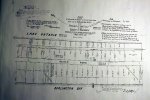
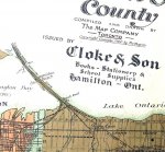
This one is dated 1877.

Click on the link, maximize the page then click on the map for the full veiw.

1877 Map
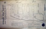
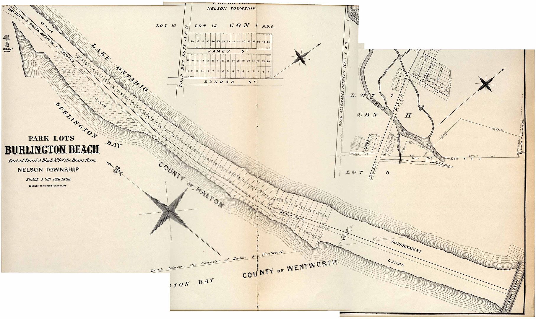
Peggy has sent me an interesting update to this map, a list of the settlers from 1874;

4 August, 1874
Sir:
In compliance with your request, and with the sanction of the Fisheries department, Ottawa, I have the honor to report and furnish you with all the present particulars, and occupied position of Burlington Beach, which is situated in the township of Saltfleet, in the South riding of Wentworth, and Province of Ontario. ..as far as my knowledge serves me, I have already by your direction communicated and pointed out to the Messrs. Thomas C. Brownjohn and Wm. F. Biggar, PLS Civil Engineers etc. etc., employed by the Mayor and Corporation, to make a survey and map of Burlington Beach under your personal superintendence… , The property of Burlington Beach owned by the Dominion Govt. as “Fishery Reserves”, “Canal Reserve”, and the land owned by the Provincial Government, etc., etc., and squatted on. I shall here describe to you as follows:
The beach proper commences in front of Peter S. Vanwagner’s Esquire etc., etc. who is the owner and occupant of lots No. 25 & 26, in B.F. Concession of the Township of Saltfleet. The beach then continues west up in front of Mr. Joseph Lutz property, situated on the main land in Saltfleet. Here is front of the Lutz residence, is the small tenement of Nehemiah Corey, an old fisherman – who occupies the Fishing Station No. 2 in Lake Ontario and fronting the beach in front of his dwelling; he has also a small garden fenced in.
I find also that Nehemiah Corey is simply noted on the assessment roll of Saltfleet, for this current year, as Householder $50, with no land whatever.
I have never heard that Mr. Lutz who owns a farm of 45 acres here on the main land had any claim to the beach in front of his farm.
Mr. G. Crossthwaite owns the two farms on the main land west of Jos. Lutz in front of which on the Beach Mortimer Corey, fisherman, occupies a house and is the Licensee of Fishing Station No. 3, Mortimer Corey squatter and built here about four years ago. M. is however an old resident, being born on Burlington Beach.
Next in order to Mr. Corey is the residence of Mr. Joseph Perry together with his stable, ? and ?
Mr. Perry is an intelligent mechanic, Master Carriage Maker, Blacksmith and Horse Shoer. Mr. Perry has resided here in this place since the ballasting of the G. W. R. was being carried out by Messrs. Harris and Adams who had the contract for ballasting up to and as late as the year 1854 (?) Joseph Perry worked for these contractors then and has continued to reside on the beach ever since up to the present time.
Mortimer Corey I find is rated as Householder $100 on the assessment roll for the year 1874 and Mr. Perry is also rated as Householder $300 on the assessment roll for the year 1874. The Beach whereon their houses etc. etc. are situated belongs to the Provincial Government and the fishing department of the Dominion Government of Canada, Ottawa.
Even the land and water “Creek” inside the post and board fence situated in part of Mr. Geo. Crossthwaite’s two farm lots, as for the south bank of the same belongs to and forms part of Burlington Beach ?, from the ? on the side road, near Joseph Perry’s down as far as Squire Peter S. Vanwagner’s farm.
The post and board fence referred to was erected there on the beach by the late George Crossthwaite, say about twelve years ago. About nine years ago Mr. George Crossthwaite through me applied to the fishing department, to buy from them this fenced in portion of Burlington Beach, here referred to. I may here further state that since Mr. George Crossthwaite’s death, this fenced in portion of Burlington Beach was included in Mr. Joseph Perry’s fishery license. One season.
Next comes Mr. G. Crossthwaite’s holding under deed of a portion of Burlington Beach. I have handed you a copy of the Patent, from the Crown of this portion of Burlington Beach. Messrs. Bigger and Brownjohn can determine the boundaries of this beach property, comprising as it does, 7 acres with two chains included therein running through the same for a public road allowance. So as to fix the location more accurately and definitely from the other portions of Burlington Beach in this locality.
There is a large barn on the property and a schoolhouse – Alexander Gray, fisherman, is rated for the year 1874, as Householder $50, and Jonathon Corey is rated for the year, 1874, Householder $100, and both are represented as Tenants to Mrs. Crossthwaite’s. I believe there is more land set apart here, as the property of Mrs. Crossthwaite, than her deed calls for.
Then comes two acres of Beach held and owned during the ballasting of the G. W. Ry. By the late John Ogilvay Hatt Esquire deceased, and I did hear there was an acre of the beach someplace in the immediate locality leased to James Gage of Barton, on which to erect a store house and wharf, - say about 40 years ago. James Gage was Mrs. Birley’s father. There comes a large piece of sand and gravel beach in front of which is situated fishing stations No. 4, 5, and 6. It runs as far up as the Tavern Stand of David Fitch. It is all an open Common. Nevertheless (?) it is all claimed by Mr. George Lottridge as his property and I believe the G. W. Ry Company made him some compensation for the ballast they took therefrom about the year 1854. The old patent from the Crown granted to a certain Colonel John Young of Haldimand, under which Mr. George Lottridge claims possession to Burlington Beach, does not legally apply to the beach in any manner whatever, as Mr. Young’s property, however he always manages to get paid for the portion of the sand beach he lays claim to, as instance the site for the filtering basins.
Mr. George Lottridge lives on the main land on the south side of the creek which divides the main land from the long Burlington Beach. It does not however appear that Mr. Geo. Lottridge has had himself assessed as the owner of this open beach, or as Freeholder of it for the year 1874, nor any previous year that I am aware of.
Next in order is the barn of David Fitch, situated on a rising knoll where is represented to me is the spot that during the war of 1812, was occupied by the Kings Head Inn. Then just a few feet south of this barn is a small dwelling house and a garden occupied at present by Duncan McGillivray, a tenant in some way to Mr. George Lottridge. Duncan is rated only as Householder $200, for the year 1874. I merely refer to this to show you that the land used as a garden is not included in the assessment roll, nor is Duncan McGillivray represented as a Tenant of Mr. George Lottridge. Duncan is a fisherman.
The next in order is the House or Tavern Station of David Fitch, who is also a fisherman, he has 5 acres of beach land together with the ? site, the land is on the north side of the Creek, running from the road near the Bridge up the beach parallel with and the full extent of the Filtering basin.
Ten (Two?) years ago, David Fitch bought all this property from Mr. George Lottridge for the sum of $800 - which he paid him for it – and since he purchased Fitch has improved the property to the extent of $350 more. Whatever Mr. George Lottridge’s title is he has disposed of these five acres of beach he had fenced in besides House and barn – for $800 cash. David is rated freeholder $300 on the assessment roll, for the year 1874. To assess him as freeholder is wrong. David Fitch is also a licensed fisherman.
Just adjacent, in rear of Fitches Tavern – is a swale, Main House and an old house, the property of the Heirs of the late Thomas Armstrong “deceased”. Thomas Armstrong I find was rated as householder $200 – for the year 1874. Then comes the filtering basin – the property of your Corporation.
I may here draw your attention to a fact, that many persons with teams, daily taking sand from the beach for building purposes, have approached very close to the picket fence of the basin – on the Lake side, for which you will please excuse my drawing your attention to it, so that you may represent the same to the proper department of the City Council.
Mr. Alexander Rolla – occupies a fenced in lot, with house, a stable and Ice House – fenced in on the Bay side. Rolla’s place is also clamed by Mr. George Lottridge. Rolla is a fisherman, is rated as Householder $20, for the year 1874, without land, and not as a Tenant of Mr. George Lottridge.

.
 

scotto

Administrator
Staff member
Feb 15, 2004
6,985
218
63
The Beach Strip
#19
Continued;
Next comes Mr. Wm. Podkins - fisherman – whose house is on the open beach. Podkins has a garden on the Bay side next to Rolla’s garden. Podkins is rated as Householder $200, for the year 1874. - Fishing Station #8 – in front of Podkins dwelling is licensed, and occupied by him.
Next comes the Isolated Residence of David Armstrong, he is employed as fireman in your Water Works Establishment at Burlington Beach, he is rated as Householder $200, for the year 1874.
John Taaffe (?) – fisherman – licensee of Station No. 9, his house stands “Isolated” on the beach, he has a small vegetable garden next to Podkins garden (?) on the bay side of the beach, he too is rated as Householder $150 for the year 1974.
Next in order comes Mr. Aaron Fletcher, a very old resident on Burlington Beach. His house, workshop “he is a boat builder and fisherman” – and a shanty stand on the open beach. He lives in the shanty and rents his house and garden “about 3 acres of land” to Mr. George Hall, fisherman. Fletcher is rated Householder $150 – for the year 1874, while George Hall, his Tenant does not appear on the assessment roll at all for the year 1874.
Richard Taaffe (?) – fisherman – House stands “Isolated” on the open beach, he is rated Householder $150 on the assessment roll for the year 1874.
Then comes Mr. John Dynes. I may here tell you that Mr. George Lottridge claims all Burlington Beach from the filtering basin up to Dynes, - deeded property both on the open, and fenced in portion of Burlington Beach. John Dynes is brotherinlaw to George Lottridge, and has a large piece of the beach on the Bay side, fenced in, that George Lottridge claims to own.
John Dynes as I understand has a patent or deed for 22 acres of beach lands. I found by the assessment roll, he is rated for 40 acres $600 and for personal property $125, as Inn Keeper and Freeholder for the year 1874. Messrs Bigger & Brownjohn, the Provincial Land Surveyors you have employed can accurately tell you how much land his patent represents him as really entitled to. It is situated between the waters of the Bay and Lake Ontario, but a reservation for a road allowance of two chains running through the centre of it is deducted, or to be deducted from the whole.
The starting point is given in the Dynes patents and the measurements of the four sides given in the description – hence I can see no difficulty in finding the locality, and the accurate quantity of land ”including the two chains for road allowance” – Mr. John Dynes is entitled to under the deed issued to his father - the late Samuel Dynes – by the Crown.
The balance he squatted on, will be a matter of right – the property of the Provincial Government, and the Fishery department – because there are two fishing stations No. 10 & No. 11, situated in Lake Ontario in front of the greater part of the beach Mr. John Dynes claims as his under deed, and his rights as a squatter.
Mr. Dynes’ house stands on the open beach, while his barn is within the fenced portion of the land on the Bay side. Messrs. Bigger & Brownjohn and myself have discussed this case carefully, and the two ? ? given it all due consideration, separating and defining the deeded property from the squatted on property Mr. John Dynes holds possession of, both within and without the fence on Burlington Beach. The surveyors and myself have arrived at this reasonable conclusion so as to show each portion distinct in their plan now in the act of preparation for you.
Next comes in order Mr. Robt. Bradt who it appears bought two acres of land this year, from John Dynes, for the sum of $150 cash, and on which Bradt has since built ? ? ? House. These two acres I am persuaded is not any part or portion of the deeded land owned by John Dynes already referred to by me.
Robt. Bradt is not rated on the Assessment roll this year at all.
Daniel McGwyne – fisherman – has a St? house and is licensed for fishing Station No. 11, Lake Ontario, he has two acres of garden situated between Thomas Martin’s and Frederick N Corey’s holdings as squatters, to be hereafter described in this report for your information. Daniel is rated as Householder $200, for the year 1874.
Zachariah Corey ? old fisherman has a small shanty - next on the beach, he is not rated on the roll for the year 1874.
William Depew lives in a small cottage belonging to Mrs. Benjamin Folds, as Tenant, he is however rated as Householder $100 on the assessment roll, for the year 1874.
Benjamin Folds has a garden fenced in, in front of his house, which stands on the open beach, although he grows vegetables in the garden, about 2 acres, which he bought this year from John Dynes for $150, still I find he is rated Householder $200 on the assessment roll for the year 1874.
The next is 3 acres of beach land belonging to an American named Clingersmith(?), he bought it several years ago from John Dynes for $150 dollars in gold, three acres, are also Government Provincial Property.
Next Mr. Thomas Martin keeps Tavern(?) It is on the open beach – with Ballroom – and buildings and stable standing back near the Lake. On the Bay side there is a dwelling house, Green(?!) House, a flower and fruit garden (?) of some extent. Martin is however rated as Householder $150 on the assessment roll for the year 1874.
The late Peter Grant Esquire “Deceased” held a nine year lease of the fishing department of this property, together with Fishing Station No: 12 in front of same, and for which he paid $20 annually. Since his death [Grant] Martin pays only ten dollars per year for the fishing. The Executors of the late Peter Grant have a claim against this property. This property and the fishing attached to it was formerly occupied by Mr. George Snooks.
The next is a point running south east into the bay from Martin’s Wharf, this is a very narrow strip, and is claimed as belonging to the fishing department as a fishing reserve.
I may here state for your information that John Dynes has all the Beach from Aaron Fletcher’s to Thomas Martin’s, fenced in on the Bay side and which he claims, and occupies as his property, except for what he sold this year to Robert Bradt Jr. , as herein alluded to.
Next in order is Frederick N. Corey, Inn Keeper, who has a large garden fenced in – he is rated as House Holder, $300, on the assessment roll, for the year 1874. Mr. Corey’s house, and Ball room is within the fenced in property on the Bay side while his stable is on the open beach in front of the dwelling house. I may here state for your information, that recently, within this year, Mr. Corey has claimed that he made a survey of all the beach from his place of residence up as far as Mrs. Anne Sherbanalle’s, during the year 1863. He also sold some years ago a piece of this open beach, in front of fishing Station No: 15, to John Brown, Merchant of this city, from whence or from whom Mr. Corey derived authority to do this I am puzzled to conjecture. This beach from the filtering basin to Mrs. Anne Sherbanalle’s is at present an open Common. Fishing Station 13 is in front of Corey’s.
We next come to Mr. John Thomas who occupies the House and premises formerly owned and in the possession(?) as squatter and fisherman of Charles Corey “deceased” during his lifetime. Some years after Charles Corey’s death his widow married Robert Bradt being(?) about to sell the same to one John Adkins, back rents being due on Fishing Station No: 14 in connection with this property. The fishing department gave consent to the transfer of the same as at present fenced in from Bradt to Adkins, on the payment of the back rents, which was carried into effect to the amount of $40. John Adkins subsequently disposed of the place to the present occupant, without the consent or sanction of the fishing department. Thomas, the present occupant would never rent the fishing in connection with his “squatter” holding, did not want the fishing at all. Mr. John Thomas is only a few years settled there and although there is about 9 acres of land in his fenced in garden he is rated simply as Householder $200 and $110(115?) on personal property, the land itself being taken no notice of whatsoever in the assessment roll for the year 1874.
 

scotto

Administrator
Staff member
Feb 15, 2004
6,985
218
63
The Beach Strip
#20
Continued;
Morris J. Birley is rated $100 but the assessment roll does not say what it is for. I, however, presume that it is for one acre of land he bought during this year from Mr. John Baldry.
John McLean has a fenced in lot, of an acres of land, next to Birley, he is Frederick N. Corey's Soninlaw. Mrs. Corey bought the lot a few years ago from Zachariah Corey and has since given it to her daughter, Mrs. John McLean.
This lot is not assessed for the year 1874. Thomas Campbell has a house and two acres of land next to McLean - he is rated as owner jointly with Wm. Smith as Householder (smudge) Inn Keeper, $300 on the assessment roll, for the year 1874. Has a stable on open beach.
Col Wm. McGivern - Merchant - has a license for fishing in Station No: 14 - he had a survey made two years ago, by the late Thomas Allen Blythe, Deputy Provincial Land Surveyor, of a portion of the open beach, in connection with his fishery, intending to build a summer residence thereon. The Colonel is not assessed for any property on Burlington Beach for the year 1874.
Then there is David Nealls - he has a fenced in lot of an acre of land with a House - he is not on the assessment roll for the year 1874.
The next lot, still on the Bay side, is owned by John Brown - Hamilton - he bought it several years ago from Frederick N. Corey. Mr. Brown is not assessed for this lot for the year 1874. Nor is he assessed for the lot which he bought from F. N. Corey, situated on the open beach.
Mr. Adam Brown owns a lot next to his brother John - but he does not appear on the assessment roll for it, for the year 1874.
Then James Rols is assessed as Householder for a lot which belongs to Wm F(?) Murray and Major O'Reilly. Rols is rated $150 for the year 1874.
Then comes Mr. S. E. Gregory, occupying an acre of land - this he bought from Mrs. Waddell of Burlington Beach last year. He is not on the assessment roll for the year 1874.
Mr. Alex Turner - Merchant - Hamilton - occupies a lot next to Gregory on which he has built a cottage this year, for a summer residence. Turner is not rated for the year 1874. He bought from Charles Abraham, who bought from Mrs. Waddell this year.
Then Charles Abraham, he has a lot he bought from Mrs. Waddell this year.
Then Thomas C. Kerr Esquire Merchant - owns a lot he is not assessed for it for the year 1874.
A lot on open beach, bay side, claimed by a Mrs. Walshe - not assessed for year 1874.
Messrs. Colonels ? B. Villiers, Brigade Major Hamilton, and Wm Button (?) Inland Revenue Department, Hamilton, and Wm. McCullough, Secretary of the Hamilton Wellington Gray and Bruce Railway - own and occupy three small lots in connection with fishing Station No. 16 of which they are licensees. They will build residences thereon which will be hereafter a credit and ornament to this locality.
Robert Hall and his mother, Anne Sherbanalle have a house and lot, Robert is a fisherman, he has fenced in about one acre of beach land this year and planted the same with trees. Robert is a useful man in this community and is rated Householder $150, on the roll of assessment for the year 1874. His mother is an old resident of Burlington Beach.
Then we have Messrs. Charles Abraham and Norris J. Birley, rated as Freeholders, $800, which is improper. They bought out Mrs. John(joan?) Baldry last year for $1800. She had no legal title there beyond length of possession and the occupancy of the fisheries for several years under an annual license. They occupy the same grounds Mrs. Baldry did, together with fishing Stations Nos: 18 and 19 in Lake Ontario and Nos: 1 and 2 in Burlington Bay, and which comprises the entire frontage of their purchase. For their licenses of the fisheries they pay annually $20. It is wrong however to rate them Freeholders, as the property is still invested in the Crown: as is also all the other property of Burlington Beach with the few exceptions I have pointed and laid down for your information. Mr. George Yale Keeps the House and is doing a flourishing Summer business.
Next in order is Mrs. Dolly Waddell, she occupies a House, Keeps a drinking Saloon "without a license" - is not rated on the assessment roll, for the year 1874.
Then we have the Ferryman's House - Henry Pross - rated as Householder, $50 on the assessment roll for this year. Henry Pross having left the Ferry - Robert Fletcher now occupies the position of Ferryman, under the Superintendence of Capt. George Thompson, Light House Keeper.
Captain George Thompson, Light House Keeper, occupies a brick dwelling house - he does not appear to be rated this year.
Captain Thompson's, Fletcher's, Waddell's, and Yale's houses and premises are all situated upon what is known on Burlington Beach as the "Canal Reserve" - as is also the Stone Light House.
Then cross the canal, and Benjamin Isaac(?), a fisherman - is the only resident there, he occupies the fisheries - and pays an annual license fee to the Fishing department - Ottawa. Although rated last year: Benjamin Isaac(?) does not appear to be rated on the assessment roll for the year 1874.
The Government Property of Burlington Beach then continues on still, until it comes to what is known and described as the "Old Outlet" from Burlington Bay to Lake Ontario, which is the dividing line between the townships of Saltfleet and Nelson. The exact position of this outlet can also be determined by the measurements laid down on the present plans of the Fisheries never paid by Benjamin Isaac(?). When measured off by your Surveyors c???ing at the beach the exact place of this outlet can even at this remote day, be again established.
I may here state for your information that in Lake Ontario, from point to point on Burlington Beach the fisheries are fixed and established by law, and in Burlington Bay or Burlington Beach, the same is in operation and is applied to the fisheries there.
In conclusion I have to state for your information that I have given Messrs. Bigger and Brownjohn all the information of the property on Burlington Beach this report to you contains to enable them to make an accurate survey of the beach for you. I have gone over the grounds and pointed out to them, the locations of all the persons concerned, which this report will more fully inform you of.
With all due regard and respect for you, and with this plain statement of facts hoping the same contains all the information which you may require.
I Have the Honor to remain
Sir
With Due Respect
Your Obedient Servant
John W. Kerr
F. Keeper
Hamilton District


To Robert Chisholm Esquire.
Chairman of Finance Committee
Corporation of the City of Hamilton.
 
Top Bottom