Old Fort on the Beach

Drogo

Moderator
Feb 8, 2005
402
2
18
#41
Hope this is a big drum-roll!

:yay:We have been working our way around the "Old Fort" for some time and surprisingly there is lots of information coming in little dribbles. Remember the Lake you face daily is just a whole bunch of dribbles. I copied all the posts on topic and re read them on the way to the doctor today. Hubby drove! I came home and have spent 6 hours using every search skill I have and garnered one little gem. I now have another timeframe, validation it was known as a fort, manned as a fort, and some names of once living souls who were connected to it. I've taken great care to document the source to keep all happy.:hail:


SOURCE
THE VOLUNTEER REVIEW AND MILITARY AND NAVAL GAZETTE
Ottawa: G. Moss (1867)
CHIM no. 8_04948_15
Vol 1, no. 15 (Apr 15, 1867)

page 8
Apr. 13

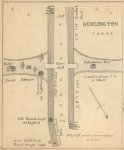
FROM WELLINGTON SQUARE

To look at the name of that place, consider the person whose name it claims, and also the names of a few of the residences, such as Bar(?)arco Terrace, Talavera Lodge, Salamanca Villa , Waterloo Road, etc. you would imagine it was inhabited by military celebraties, and it is not for want of energy on the part of the people themselves that they are not such. For the present, however, not even a company has it’s head-quarters here. But many of the inhabitants belong to the force elsewhere. Through the energy of Mr. W. Kerns (now Ensign of one of the neighbouring companies), there was a fine company raised. They were first organized as Infantry and accepted as such. Lieut. Col. Villiers afterwards received orders to garrison (or rather to prepare to do so) the fort at the beach, which commands the entrance to Burlington Bay, and as Wellington Square was considered the best place to have such an artillery, but has not been gazetted yet. The men are very patient, but are very anxious to know their destiny, and to get to work in some branch of the defensive force. :tbu:


Note
Until today I have been under the misconception that Head Of The Lake and Burlington Heights were one and the same. Today I read that Head of the Lake is the Beach and Burlington Heights (I one I was already sure of) is the area of Dundurn Castle and the Cemetery where the earthworks from 1812 are. If this is correct I have seen other notations of something going on at Burlington Heights (War 1812 era) and barrack and guns at the Head Of The Lake in the same sentence. I will be hunting them up again.

With the information we have we can start to put together some possibilities. Please note the following is one scenerio of the fort and not to be taken as historical fact. :nonono:

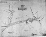
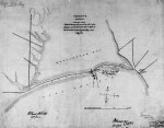
There is a strong possibility that the fort wasn't in existence when Lady Simcoe was on the beach. With all the confirmed or noncomfired stories of the Burlington Races they never mention support from or the Americans backing away from the presence of a fort at the canal. Now it would be prudent after that time to look at defending a very valuable port and safe haven after the American invasion. Now comes the part of finding out who and why it was built. Someone, some militia or British regulars (not likely) would have manned it. Someone looked after a light they built there. It could have become unnecessary a few years later. Then along comes the Rebellion of 1837. Again there is a need to protect the harbour. Militia goes home and the fort is used for whoever knows what. Then the Fenians arrive 1866. The above puts together a unit in /67. Probably not a coincidence at all. I'm sure that all the time before this some unit at periodic times used that fort or manned that fort. But this article being 1867 is very significant. It was obviously kept well enough that it was usable. The new canal was going. The limestone lighthouse was lite and I think George Thompson was there. Surprising he doesn't mention it. At least I didn't see mention of it but I will now go back and try again for the early years. Chisholm was running his business but I can't find mention of it connected with his dealings. This fort didn't die off in the early years so why is it so ignored? Still lots of work to do but one more piece of the puzzle is in place.

NOTE SCOTTO
As it was manned in 1867 there is a good possiblity that it was there for the loco picture and it might be the older building however it is still mentioned and mapped as being north of the old canal which wasn't that close to the new one. For that picture the new canal would be almost on top of the original.

We may have just learned the name of the Old Fort

THE FORT
or
THE FORT at the BEACH
or
THE FORT at the BURLINGTON CANAL

as in the article it wasn't referred to with military reverence as Fort George or Fort Erie or Fort York. Just the fort.

Hope someone else is smiling cause I am,

Drogo
 

scotto

Administrator
Staff member
Feb 15, 2004
6,985
218
63
The Beach Strip
#42
Thanks Drogo;
I guess you didn't see anything on the Innkeeper from the Kingshead Inn, William Bates??:p
I never see much written about Wellington Square in reference to the War of 1812, which I assume is the area in Burlington near what is now Brant St?

Yes, that one loco picture has a very large building in the background which could be considered fortified for the day. It has some resemblance to some of the structures you would see at Fort Henry or Fort York.
Good find Drogo and some good reading for me.
Thanks again! :tbu:
 

Attachments

Fred Briggs

Beach History Moderator
May 27, 2004
64
0
6
86
Stoney Creek
hamiltonbeachcommunity.com
#43
The Old Fort, and other things

I have discussed these matters privately at length with D. Smith, but I thought I should post something for the record, and for everyone else who may be wondering abut the answers to the questions.
The reference to Samuel Hatt and the King’s Head Inn was quoted in The Head Of The Lake, A History of Wentworth County, by Charles Murray Johnson, published by The Wentworth County Council in 1958, with a second edition in 1967. It’s available in the Hamilton Public Library, except for when it is “out” (like now – D.S. has borrowed it!) This is the quote:
“The Yankeys [sic] … visited the Head of the Lake with two Schooners and I believe about 200 men – Major FitzGerald of the 49th was stationed there, he had about 14 Regulars and 25 Militia under his Command. I met with him within two miles of the Beach with a reinforcement of about 30 choice Militia, but he, I think properly too, thought proper to retire to my station at Durand’s [probably near the foot of the Mountain on the present line of John Street] – The Yankeys burnt the Government House [King’s head Inn], but did no other mischief, they sailed the next day …”
Those words between the “[“ and the “]” were added by the author, C.M. Johnson. The original report is on record and the reference he gave was:
Samuel Hatt to Colonel Land (?), 15 May1813; P.A.C., Hamilton Papers.
I order to fill in the blanks ( … ) I contacted Archives Canada (formerly Public Archives Canada (P.A.C.) but they finally reported back to me that they had gone through the “Hamilton Papers” and did not find the reference. I’m unsure if the “Hamilton Papers” refers to papers about the city of Hamilton, or a man named Hamilton (there were more than one so named in this area)0.
Captain Samuel Hatt was in charge of the 5th Lincoln Militia. The 4th Lincoln Militia, the 5th Lincoln Militia, and the 2nd Regiment of York were to be joined together to form one part of the Incorporated Militia.

Militia General Orders.
HEADQUARTERS, YORK, 3d April, 1813.
His Honor the Major-General commanding is pleased to direct that a detachment of the militia, consisting of one major, one captain, one lieutenant, one ensign, three sergeants and sixty privates be formed to join a detachment of troops of the line to be stationed at Jones's and houses adjacent at the head of the lake. The under-mentioned regiments will furnish the following quota:
Maj'r. Capt. Lt. Ens. Sergts. Privates.
2nd Regt. York 1 1 20
4th Lincoln 1 1 20
5th Lincoln 1 1 1 20
1 1 1 1 3 60
His Honor approves of Captain Willm. Crooks for this detachment and directs active, intelligent subalterns be selected. The arms and accoutrements collected by Colonel Beasley, (if not sent to Fort George), directed to be transferred to Major Simons will furnish equipments to the detachment from the 2d Regt. of York.
By order,
AENEAS SHAW,
Adjt. Gen'l, Militia.

On April 7th there was an order to establish three Incorporated Militia forces for the defense of Lake Erie. There were to be 80 rank and file at Turkey Point, 50 rank and file at Dover Mills (now Port Dover), and 20 rank and file at Port Talbot, plus a stated number of officers of various ranks at each location. The men were to be raised as follows: 100 rank and file from the 1st & 2nd regiments of Norfolk, 30 from the 1st Regt. of Oxford, and 20 from the 1st Regt. Of Middlesex, which amounted to 150 rank and file, plus their officers. They were to be relieved monthly. Thus, only half of the militia would be on duty at any particular time.
Exactly how and why Major Fitzgerald of the 49th Regiment, was at the King’s Head Inn on May 10th (probable date of the burning) isn’t yet clear to me, but on May 8th General Vincent ordered Lieut.-Colonel Claus to be prepared to take over the command of the garrison at Fort George if the 49th Regiment was required to move out to help defend Burlington Heights from an attack that seemed to be imminent.
I thank D. Smith for the John Norton lead regarding the breaking of Brant’s widows windows. In our further discussions, we have developed a little more information but it is still under investigation and too arcane to post here.

In a follow-up posting by scotto, he says he has never heard of William Bates. It must have slipped his mind. For any others who have forgotten, William Bates was the first civilian keeper of the King’s Head Inn (when it first opened, Government House was managed by military staff). There’s a lot more I could say about William Bates, but it is very much a side issue to the “Old Fort” thread, so I’ll keep it for another time.

I have also been developing what I believe to be the story of the “Old Fort” at the canal, but I haven’t been able to finish this line of investigation because of several others I’m trying to follow, and right now they have priority. I can say that the old fort that shows on the map of the canal area has nothing to do with the old outlet, the War of 1812, or even the Fenian Raids.
Sit tight – it’s starting to develop into a fascinating tale! I may drop a few of the facts here before I finish my video, in case I finish before the video! Thanks for the new lead, Drogo! We’re both working in the same time frame now!

And one other aside to Drago’s comment – as I see it, the Head of the Lake is no more the equivalent to the Beach, or Burlington Heights, than King and James is equivalent to Hamilton.
Head of the Lake simply means the “end of the lake furthest from its outflow” I believe the French equivalent (and it probably predates our Head of the Lake) is Fond du Lac. As I read it, it indicates a large area rather than a specific point or feature. The old, proper, name for the Beach was Burlington Beach (post Long Beach, of course). We all know where and what Burlington Heights is. However, sometimes it was shortened to Burlington in dispatches. On some other occasions Burlington in dispatches means Burlington Beach. Of course, Burlington was also used paired with other words, like Burlington Plain, and that very peculiar Burlington Bay, but let’s not get into that one right now!
Remembering that there was no place in Upper Canada named Burlington, it’s easy to see that it could be shortened and used to represent either Burlington Beach, Burlington Heights, or even some times, Burlington Bay – we just don’t know whether the latter was east or west of Burlington Beach!
Anyway, all of the above are at the Head of the Lake, remember there was no Hamilton yet, and Head of the Lake didn’t specify anything specifically! And other than Brant’s Block, there was nothing at the present site of Burlington that could be called anything other than the Head of the Lake! Except that I have seen it called “Ancaster” as that was the nearest bit of civilization at that time!

I’d still like to get in touch with you, Drago, so we could thrash some of this out together instead of publicly. I think we each have material that would be useful to the other. You can email me through this site, or my web page at http://beachvideo.info. Then you could give me your phone number, and I could call you without any worry about long distance charges.

By the way, I also pointed out that map error at and to the Joseph Brant Museum more than a year ago. I’m disappointed to hear that they still haven’t fixed it!
 

Drogo

Moderator
Feb 8, 2005
402
2
18
#44
I found the information, on Head of the Lake, on a record from 1837. I tend to think people of that era were somewhat familiar with the references of the time period. I could be wrong but you have to go with the written word unless you have an old relative still kicking around to get it from the horse's mouth. I have found sources for tons of old records. I'm after Bates now to answer Scotto's query. Hang on, I'll find something. All my research will be made available on my free local history website. I'm back to working on it again. Will be, shortly, posting the Gazette columns from George Thompson, Spectator daily accounts of the Fenian Raids, George Thompson's references to the Corey family of the beach (will be on another family site) and my findings on the Old Fort. When uploaded I will post the URLs so anyone interested can go and take a look.

Also a clarification on Wellington Square. Yes it is the area of Brant Street. Includes the present day Wellington Square Church. I'm also researching that area because my great great grandfather anchored his ships there so I have interest in the wharfs and ship builders.
 

D Smith

Registered User
Mar 4, 2008
4
0
0
#45
History of the Canal

Not sure if this map of the Burlington canal is of interest to anyone. There is no dating on the image but the written article with the map indicates it may have been 1856. Follow this link:

http://www.maritimehistoryofthegreatlakes.ca/documents/Hodder/default.asp?ID=s029

On the side bar, choose "Port of Hamilton and Burlington Canal"

The information seems to be from a book by Edward M. Hodder M.D. called "The Harbours and Ports of Lake Ontario, In a Series of Charts, Accompanied by a Description of Each; Together with the Lighthouses, Harbour Lights, Depth of Water, Courses and distances &c. &c. Compiled from Authentic Sources, The Charts of Capt. Owen and Lieut. Herbert, From Recent Surveys, As well as From Personal Observations" Toronto: Maclear & Co., 16 King Street East. 1857.
Now, did you get all that ! :)

If someone could check out the link and upload the image to this forum for everyone to see, I think it might be worthwhile. (I'm a little technologically challenged when it comes to this task !)

There are a couple of very interesting passages which make very good reading.....

"The old lighthouse which stood near the centre of the canal on the isthmus was destroyed by fire, and a new one had been erected on the east end of the south pier, with a stationary bright light, the old beacon light not being used."

Also this ..... "During the year 1856 several alterations and repairs have been made. Additional crib-work has been added to the eastern or Lake extremity of the South Pier, 300 feet in length, and considerably higher than the old work. Instead of following the old line, or N.E. 1/2 E. the new part runs a more northerly course or nearly N.E. by N. which has had the effect of making the entrance still more difficult than it was before, particularly when the wind is strong from the east or south. I have heard from persons residing on the spot, that it is next to impossible for sailing vessels to enter this canal during a gale from the E. or S.E. without coming in contact with the end of the north pier, whereby the weaker of the two is likely to be seriously damaged; to obviate this catastrophe, however, several oak piles have been driven into the bottom, which serve the purpose of a fender, and materially lessen the concussion that would otherwise take place. The same wise arrangement has been made at the opening into the bay, except that the new work is added to the north pier, and the fenders to the south"....

Just another little slice of history for those of you interested in the canal.

Daphne
 

scotto

Administrator
Staff member
Feb 15, 2004
6,985
218
63
The Beach Strip
#46
Thanks for the history Daphne, I see there is no mention of the Fort and it is not shown on the map as well. I don't believe I have ever seen that map before.
BTW; if you want a picture from the Net, just right click on the picture and choose the "save picture as" option.
 

Attachments

Drogo

Moderator
Feb 8, 2005
402
2
18
#47
3-gun Battery at the canal

Well you can thank Fort Mississauga for the lead that found this picture. This is an official drawing of the 3-gun battery at the Burlington Canal (erected December 1861) to defend the entrance to the Bay. There is a notation that the guns are not mounted and there isn't a magazine.

This is the second piece I've provided that a defense was there. The other is on this list. It makes note that the Wellington Square Militia is going to be sent to man it. That was later in the 1860s so obviously they weren't panicking about an attack until the Fenian issue arose.

The image is my source as stated on it.

Now I can go back to finding my first interest which was the original defense at the natural outlet of the Bay.
 

Attachments

Drogo

Moderator
Feb 8, 2005
402
2
18
#48
Burlington Outlet Barricks and burning of same area

I just came into poccession of a massive research library (which I guess I am now). It consists of 87 2" or 3" absolutely full binders. It covers the timeframe of about 1770 to 1820. I have about 10 binders of Haldimand Papers, about the same of Carleton Papers, Daniel Claus Papers, 4 binders of Montreal Gazette, 4 binders of the United States Prisoners of War, Land Index and records for alot of this area, Naval Papers, Fort George orders, Fort Niagara papers and tons of Loyalist claims and War of 1812 Losses Claims.
With all of this I just opened one book and there was Richard Hatt's Claims for damages. I have both his farm and mill in Ancaster and his Store Houses at the Outlet to Burlington Bay. There are letters from John Brant, William Bates, John Chisholm and Ansehal Davis. They are all uniform on the following things,
-His Majesty's Troops, Militia, Artillery, and one mentions Prisoners used Hatt's two Storehouses at the Outlet from 1813 to end of War.
-the troops pulled the weather boards off the larger Store, cut the Braces and some of the Posts and a storm blew it down after that
-they burned the rest of the building
-he had about 15 barrels of Potashes in the two Stores and these were destroyed.

After this John Chisholm used alot of the boards to finish the Barracks.
Asehal Davis swears to this as he was in the Militia and worked on it

This might also put to rest question of did the Americans also burn it. Apparently not.
 

Drogo

Moderator
Feb 8, 2005
402
2
18
#50
Yes and it's a portion of the work there. I will be getting more as he goes through books. He's getting out of the business and I called to see if he could tell me where to get records on military fortification War of 1812. I was told to bring a truck.
 

Sharla1

Registered User
Oct 15, 2009
1,262
17
38
68
#51
I don't think I had any family in the war of 1812 or WW1. I had a few uncles and my father in WW2. And my 2nd great grandfather was in the civil war. And his grandfather my 4th great grandfather was in the Revolutionary war and he was 2nd LT. to George Washington. My second great grandfather did die POW in the civil war. All of the rest in WW2 and Revolutionary war survived the wars.
 
Last edited:

Drogo

Moderator
Feb 8, 2005
402
2
18
#52
Old Hat? Excuse the Pun

Well other than Sharla's enthusiam I guess the Richard Hatt information wasn't of interest to anyone. I thought it wrapped things up nicely. Just a couple of other things I'd like to wrap up to my satisfaction. One is to put the official name on the Outlet fortification (just waiting for confirmation) and secondly is to actually find the location of the original outlet. I have enough information that with a good calculator, long tape measure, and allowance for wind (blowing my tape) I should be able to walk to it. I sent Scott my overlay of where I think it was. Now go and prove it.

I'll be watching the list but I'm off to go through the Saltfleet claims I have and see if any of my relatives are in there.
 

Sharla1

Registered User
Oct 15, 2009
1,262
17
38
68
#53
I hated history in school. Now I love it, go figure.

I would have my head burried in those like crazy.

I hope you don't find any surprises like some of your family was wanted for anything. LOL joking
 

Drogo

Moderator
Feb 8, 2005
402
2
18
#54
Oh the dirty rotten scondrels are the most fun. I've been doing genealogy for over 20 years so I have one of just about everything. The Beach is special to me because I was born there. My Mother was born in the Old Pump House on the north end of the Beach. Well if you really like history then go for it. You are following a line of history. Try Google books. There is alot on the Beach. Some really old history.
 

Sharla1

Registered User
Oct 15, 2009
1,262
17
38
68
#55
I think we all have some shady characters in our family trees. I can't even trace my mother's father's side since my great grandfather was a mystery man. Very taboo that was in 1888 to have a child out of wedlock.

I email a distant relative of mine in Minnesota a lot. And on her search of her tree she found a shocker of some gory murders in the 1600s. That was before her line married into my line so they weren't related to me.
 
Last edited:

Drogo

Moderator
Feb 8, 2005
402
2
18
#56
I think we all have some shady characters in our family trees. I can't even trace my mother's father's side since my great grandfather was a mystery man. Very taboo that was in 1888 to have a child out of wedlock.
Oh that doesn't mean they can't be found. Most places were mandatory registration then. I found my neighbours secret in 1/2 hour. Of course where they were born makes a difference. I have access to Ontario and Quebec. England is more trial and error to get the right one. Ireland you couldn't get the information if they were standing beside you.
 

scotto

Administrator
Staff member
Feb 15, 2004
6,985
218
63
The Beach Strip
#57
An update with some real facts.

Sent in by David O'Reilly
It was on June 18, 1812 that the United States declared war against Britain.
No longer willing to accept naval blockades interrupting their trade lines and the impressment of American seamen by British orders-in-council, the Americans hoped that the threat of war would force the British into offering concessions. Although the British did rescind some measures, negotiations broke off resulting in the declaration of war.
Read More;
http://www.museumsofburlington.com/.../69/original/war_of_1812_paper.pdf?1331327111
 

David O'Reilly

Registered User
Dec 15, 2012
481
4
18
#58
Fred
“On the 1815 Saltfleet Map, scotto has stated The school house on Van Wagner's (now Baranga's) can be seen. The two-storey poured concrete Van Wagner's Beach schoolhouse with a basement wasn't built until 1905, and that building was modified several times before it was closed, and finally converted to Baranga's, and then there were more additions that brought it up to its present size. Prior to 1905, the previous schoolhouse at Van Wagner's Beach was a single storey frame building with one classroom and a separate room for the teacher. That was built around 1830 or 1840, so it would have been there (a little to the east of the later cement school) in 1875. However, it wouldn't be any larger than all the other buildings on Van Wagner's and Burlington Beach, which are represented by small black squares. Why it would be represented by such a large drawing, in a 3-dimensional side view, is a bit of a mystery.”

Fred, I’ve come across a vague reference to a store house on the beach in 1844. I wonder if it is one of the buildings shown on these maps.

1844 – “The season of 1844 opened with an incident of somewhat melodramatic quality. In the stygian darkness of a January night, a man was making his silent way along Burlington Beach. He was John Henry Palmer, a zealous Custom House Officer, acting on a tip, and on his arrival at the Piers, he apprehended the schooner WILLIAM JONES, engaged in the nefarious business of smuggling. He also found that a considerable amount of her cargo had already been secreted in the storehouse of Mr. Russell, the contractor on the Canal job.”
http://www.maritimehistoryofthegreatlakes.ca/documents/Brookes/default.asp?ID=Y1844
 

David O'Reilly

Registered User
Dec 15, 2012
481
4
18
#59
D Smith
02-16-2009, 12:21 PM
Not sure if this map of the Burlington canal is of interest to anyone. There is no dating on the image but the written article with the map indicates it may have been 1856. Follow this link:

http://www.halinet.on.ca/GreatLakes/documents/Hodder/

On the side bar, choose "Port of Hamilton and Burlington Canal"

The information seems to be from a book by Edward M. Hodder M.D. called "The Harbours and Ports of Lake Ontario, In a Series of Charts, Accompanied by a Description of Each; Together with the Lighthouses, Harbour Lights, Depth of Water, Courses and distances &c. &c. Compiled from Authentic Sources, The Charts of Capt. Owen and Lieut. Herbert, From Recent Surveys, As well as From Personal Observations" Toronto: Maclear & Co., 16 King Street East. 1857.
Now, did you get all that ! :)

If someone could check out the link and upload the image to this forum for everyone to see, I think it might be worthwhile. (I'm a little technologically challenged when it comes to this task !)

There are a couple of very interesting passages which make very good reading.....

"The old lighthouse which stood near the centre of the canal on the isthmus was destroyed by fire, and a new one had been erected on the east end of the south pier, with a stationary bright light, the old beacon light not being used."

Also this ..... "During the year 1856 several alterations and repairs have been made. Additional crib-work has been added to the eastern or Lake extremity of the South Pier, 300 feet in length, and considerably higher than the old work. Instead of following the old line, or N.E. 1/2 E. the new part runs a more northerly course or nearly N.E. by N. which has had the effect of making the entrance still more difficult than it was before, particularly when the wind is strong from the east or south. I have heard from persons residing on the spot, that it is next to impossible for sailing vessels to enter this canal during a gale from the E. or S.E. without coming in contact with the end of the north pier, whereby the weaker of the two is likely to be seriously damaged; to obviate this catastrophe, however, several oak piles have been driven into the bottom, which serve the purpose of a fender, and materially lessen the concussion that would otherwise take place. The same wise arrangement has been made at the opening into the bay, except that the new work is added to the north pier, and the fenders to the south"....

Just another little slice of history for those of you interested in the canal.

Hellow D Smith, this is great information on changes to the canal and piers. If you have anything more, would you be interested in posting it along with this, to Drogo’s thread ‘From Outlet to Canal’?
 
Top Bottom