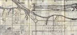
What I'm looking for are photos, articles, maps, contacts for other people, or anything that might help me with the history of these two sites. The first one was a small cottage we rented (when I was aged 2 to 4) from the owner of the land that now holds the naval memorial stones to the sailors of the Hamilton and Scourge. The owner's house was situated right where those rows of stones are now. Our cottage, and three others, were a few hundred feet away closer to the turtle pond that has the pedestrian bridge going over it. There were also at least two large greenhouses and other smaller sheds. My parents always referred to it as 'Howard's" and I believe the owner ran the business as "John Howard Florist". All the rest of the property was covered with rows and rows of all kinds of flowers all the way to the highway. Back then, the large traffic circle butted up against the property. When I was four years old, the City was in the process of buying out the owner to make way for Confederation Park to eventually take over the land and as such, we had to move.
The City then offered to rent us our next house, just down the road at 190 Nash Rd North, right across from the old Hutch's Dingley Dell. I lived there from four to eight years old and have many great memories of the beach, Hutch's, the orchards across from our house and the forest and fields around us. The house now, with a new address of 585 Van Wagner's Beach Rd, is used as the offices and yard/maintenance area for the park people. My aunt, uncle and cousins rented the house next to us, right next to the stream. It was a treat, after 50 years, to be able to go inside the office and have a tour through the old house again. Even with some of the changes made over the years, it was still very much 'home'.
I was hoping, that by joining your HBC site, I might find others who lived in the area or know some of the background to these properties. I realize that most of your members, from what I have read, are more a part of the beach community running from the stop lights at Van Wagner's Beach Rd all the way to the bridge and beyond, but I have my fingers crossed that some of those will also have family history or knowledge going in the other direction.
This then is a brief background of my reasons for joining and hope I can fit in at the site.